File:Generalgouvernement with 2nd Polish Republic, "Lebensraum im Osten", and current borders.jpg

Size of this preview: 800 × 493 pixels. Other resolutions: 320 × 197 pixels | 640 × 394 pixels | 907 × 559 pixels.
Original file (907 × 559 pixels, file size: 89 KB, MIME type: image/jpeg)
Captions
Captions
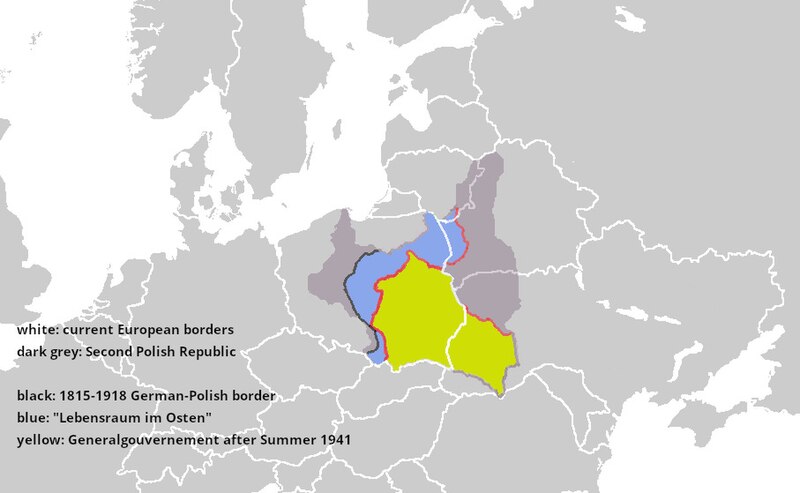
Map of Generalgouvernement in comparison to Second Polish Republic
Summary edit
| Description |
English: Used European blank map with current borders, added Second Polish Republic, added German-Polish borders after the Vienna Congress of 1815, outlined in blue German annexations beyond the 1815-1918 border, and added Generalgouvernement (shape after Summer 1941). |
| Date | |
| Source | Own work |
| Author | Der Eberswalder |
Licensing edit
I, the copyright holder of this work, hereby publish it under the following license:
This file is licensed under the Creative Commons Attribution-Share Alike 4.0 International license.
- You are free:
- to share – to copy, distribute and transmit the work
- to remix – to adapt the work
- Under the following conditions:
- attribution – You must give appropriate credit, provide a link to the license, and indicate if changes were made. You may do so in any reasonable manner, but not in any way that suggests the licensor endorses you or your use.
- share alike – If you remix, transform, or build upon the material, you must distribute your contributions under the same or compatible license as the original.
File history
Click on a date/time to view the file as it appeared at that time.
| Date/Time | Thumbnail | Dimensions | User | Comment | |
|---|---|---|---|---|---|
| current | 16:02, 14 February 2022 | | 907 × 559 (89 KB) | Der Eberswalder (talk | contribs) | Better outline of the Second Polish Republic |
| 11:49, 14 February 2022 |  | 907 × 559 (86 KB) | Der Eberswalder (talk | contribs) | Uploaded own work with UploadWizard |
You cannot overwrite this file.
File usage on Commons
The following page uses this file:
File usage on other wikis
The following other wikis use this file:
- Usage on en.wikipedia.org
- Usage on it.wikipedia.org
- Usage on pt.wikipedia.org