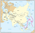
File:Geographic Boundaries of the First and Second Island Chains.png

Original file (1,387 × 1,340 pixels, file size: 51 KB, MIME type: image/png)
Captions
Captions
| DescriptionGeographic Boundaries of the First and Second Island Chains.png | Figure 2. Geographic Boundaries of the First and Second Island Chains | ||||
| Date | 05/23/06 | ||||
| Source | Image:China Report 2006.pdf | ||||
| Author | DoD | ||||
| Permission (Reusing this file) |
|
File history
Click on a date/time to view the file as it appeared at that time.
| Date/Time | Thumbnail | Dimensions | User | Comment | |
|---|---|---|---|---|---|
| current | 00:24, 8 March 2018 |  | 1,387 × 1,340 (51 KB) | Ras67 (talk | contribs) | new extracted and cropped from the PDF |
| 11:32, 7 November 2016 |  | 1,434 × 1,378 (104 KB) | Ricky22p (talk | contribs) | Better quality version extracted from the same PDF file using GNOME Document Viewer. | |
| 08:29, 26 May 2006 |  | 1,431 × 1,121 (89 KB) | Shizhao (talk | contribs) | {{Information |Description=Figure 2. Geographic Boundaries of the First and Second Island Chains |Source=Image:China Report 2006.pdf |Date=05/23/06 |Author=DoD |Permission={{PD-USGov-Military}} |other_versions= }} [[Category:Chinas' Military Power Re |
You cannot overwrite this file.
File usage on Commons
The following page uses this file:
File usage on other wikis
The following other wikis use this file:
- Usage on ar.wikipedia.org
- Usage on de.wikipedia.org
- Usage on en.wikipedia.org
- Usage on fa.wikipedia.org
- Usage on fr.wikipedia.org
- Usage on id.wikipedia.org
- Usage on it.wikipedia.org
- Usage on ja.wikipedia.org
- Usage on ko.wikipedia.org
- Usage on no.wikipedia.org
- Usage on pt.wikipedia.org
- Usage on uk.wikipedia.org
- Usage on vi.wikipedia.org
- Usage on www.wikidata.org
- Usage on zh.wikipedia.org
Metadata
This file contains additional information such as Exif metadata which may have been added by the digital camera, scanner, or software program used to create or digitize it. If the file has been modified from its original state, some details such as the timestamp may not fully reflect those of the original file. The timestamp is only as accurate as the clock in the camera, and it may be completely wrong.
| Horizontal resolution | 107.92 dpc |
|---|---|
| Vertical resolution | 107.92 dpc |
