File:Geography avesta grenet.png

Size of this preview: 800 × 475 pixels. Other resolutions: 320 × 190 pixels | 640 × 380 pixels | 1,024 × 607 pixels | 1,280 × 759 pixels | 2,330 × 1,382 pixels.
Original file (2,330 × 1,382 pixels, file size: 4.06 MB, MIME type: image/png)
Captions
Captions
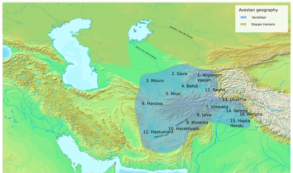
Approximate location of place names mentioned in the Avesta
Summary edit
| Title |
Geography of the Avesta according to Grenet |
| Description |
English: This is a map which shows the approximate location of place names mentioned in the Avesta. The localizations are based on the works by Franz Grenet. |
| Date | |
| Source | Own work; background taken from demis.nl Mapper.[dead link], which are public domain. |
| Creator | |
| Geotemporal data | |
| Date depicted | between 900 and 500 BC |
| Map type | historical map |
| Heading |
 |
| Georeferencing | If inappropriate please set warp_status = skip to hide. |
| Archival data | |
| Notes | made with Inkscape; background from demis.nl Mapper.[dead link], which are public domain. |
| artwork-references |
List of source materials:
|
Licensing edit
I, the copyright holder of this work, hereby publish it under the following license:
This file is licensed under the Creative Commons Attribution-Share Alike 4.0 International license.
- You are free:
- to share – to copy, distribute and transmit the work
- to remix – to adapt the work
- Under the following conditions:
- attribution – You must give appropriate credit, provide a link to the license, and indicate if changes were made. You may do so in any reasonable manner, but not in any way that suggests the licensor endorses you or your use.
- share alike – If you remix, transform, or build upon the material, you must distribute your contributions under the same or compatible license as the original.
File history
Click on a date/time to view the file as it appeared at that time.
| Date/Time | Thumbnail | Dimensions | User | Comment | |
|---|---|---|---|---|---|
| current | 07:42, 27 November 2023 | | 2,330 × 1,382 (4.06 MB) | Kjansen86 (talk | contribs) | revised the colors |
| 07:20, 20 August 2022 |  | 2,291 × 1,363 (4.28 MB) | Kjansen86 (talk | contribs) | corrected the position of Ghazni | |
| 13:20, 19 August 2022 |  | 2,291 × 1,363 (4.27 MB) | Kjansen86 (talk | contribs) | added labels for some rivers and cities | |
| 20:10, 18 August 2022 |  | 2,291 × 1,363 (4.26 MB) | Kjansen86 (talk | contribs) | changed background to DEMIS Mapserver | |
| 18:19, 13 August 2022 |  | 1,716 × 1,644 (4.45 MB) | Kjansen86 (talk | contribs) | Uploaded own work with UploadWizard |
You cannot overwrite this file.
File usage on Commons
There are no pages that use this file.
File usage on other wikis
The following other wikis use this file:
- Usage on fa.wikipedia.org