File:Geological Trail Station 1 sign.JPG

Original file (4,608 × 3,072 pixels, file size: 8.18 MB, MIME type: image/jpeg)
Captions
Captions
Summary edit
| Description |
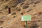
Deutsch: Schild des Geological Trail:
English: Sign of Geological Trail:
|
| Date | |
| Source | Own work |
| Author | Jotpe |
| Place[1] | Deutsch: סינגל הרי נפתלי, Yigal Alon, Bne Beitecha, Kirjat Schmona, Nordbezirk, Israel English: סינגל הרי נפתלי, Yigal Alon, Bne Beitecha, Kiryat Shmona, North District, Israel עברית: סינגל הרי נפתלי, Yigal Alon, Bne Beitecha, קרית שמונה, מחוז הצפון, ישראל |
| Image Number | 95 |
| Height | 304 |
| Camera location | | View this and other nearby images on: OpenStreetMap |
|---|
edit
-
 Naftali Cliffs.JPG
 -
 Geological Trail Station 1 sign.JPG
 -
 Naftali view into Hula Valley.JPG
 -
 Manara Cable Car 1.JPG
 -
 Manara Cable Car 2.JPG
 -
 Geological Campsite.JPG


The production, editing or release of this file was supported by the Community-Budget of Wikimedia Deutschland. To see other files made with the support of Wikimedia Deutschland, please see the category Supported by Wikimedia Deutschland. |
Licensing edit
- You are free:
- to share – to copy, distribute and transmit the work
- to remix – to adapt the work
- Under the following conditions:
- attribution – You must give appropriate credit, provide a link to the license, and indicate if changes were made. You may do so in any reasonable manner, but not in any way that suggests the licensor endorses you or your use.
- share alike – If you remix, transform, or build upon the material, you must distribute your contributions under the same or compatible license as the original.
edit
Sources edit
File history
Click on a date/time to view the file as it appeared at that time.
| Date/Time | Thumbnail | Dimensions | User | Comment | |
|---|---|---|---|---|---|
| current | 06:45, 7 February 2015 | | 4,608 × 3,072 (8.18 MB) | Jotpe (talk | contribs) |
You cannot overwrite this file.
File usage on Commons
The following 7 pages use this file: