File:Geologische Karte Taunus.png

Size of this preview: 732 × 600 pixels. Other resolutions: 293 × 240 pixels | 586 × 480 pixels | 938 × 768 pixels | 1,250 × 1,024 pixels | 2,500 × 2,048 pixels | 3,120 × 2,556 pixels.
Original file (3,120 × 2,556 pixels, file size: 1.75 MB, MIME type: image/png)
Captions
Captions
Add a one-line explanation of what this file represents
Summary edit
| Description |
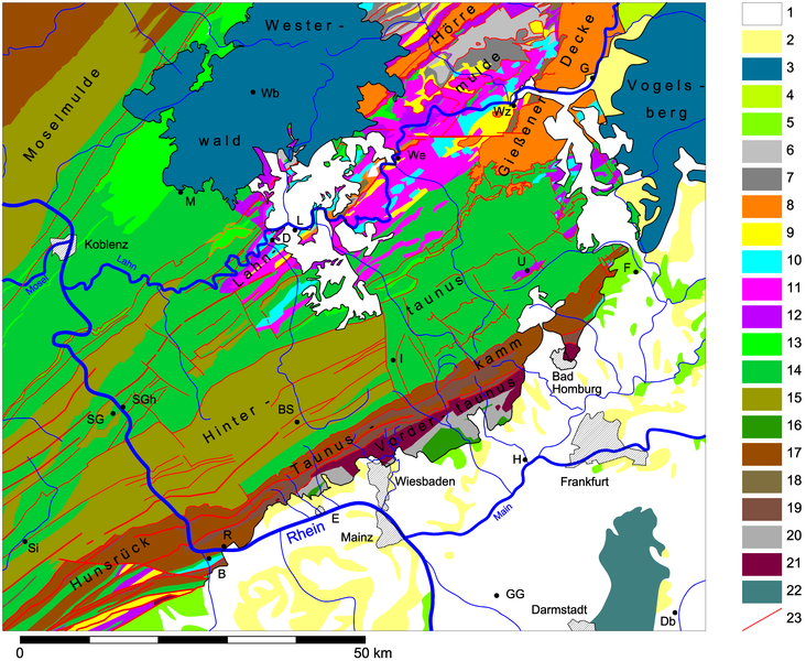
English: Geological map of Taunus, Germany
Deutsch: Geologische Karte des Taunus |
| Date | |
| Source | Own work |
| Author | Jo Weber |
| Permission (Reusing this file) |
GFDL / CC-BY-SA 3.0 |
Legend edit
| Nr. | Einheit | Bemerkungen | Nr. | Einheit | Bemerkungen |
| 1 | Quartär | 2 | Tertiär | ||
| 3 | Tertiär, Vulkanite | Westerwald + Vogelsberg | 4 | Trias, Buntsandstein | |
| 5 | Perm, Rotliegendes | 6 | Unterkarbon | Kulmfazies (Tonschiefer + Grauwacken) | |
| 7 | Unterkarbon | Deckdiabas | 8 | Oberdevon - Unterkarbon | Gießener Decke, Hörre, Gaudernbacher Schichten |
| 9 | Oberdevon | 10 | Mitteldevon - U.Oberdevon, Givet - Frasnes | Massenkalk | |
| 11 | Mitteldevon, Givet | Schalstein | 12 | Mitteldevon | |
| 13 | Unterdevon, Ems | Emsquarzit | 14 | Unterdevon, Ems | |
| 15 | Unterdevon, ?Siegen - Ems | Hunsrückschiefer | 16 | Unterdevon, ?Siegen - Ems | Lorsbacher Schiefer |
| 17 | Unterdevon, Siegen | 18 | Unterdevon, ungegliedert | ||
| 19 | Unterdevon, Gedinne | Graue Phyllite, Bunte Schiefer | 20 | Silur | Eppsteiner Schiefer |
| 21 | Ordovizium | Metavulkanite | 22 | Kristallin des Odenwaldes | |
| 23 | Störungen |
Cities edit
| BS | Bad Schwalbach | B | Bingen |
| Db | Dieburg | D | Dietz |
| E | Eltville | F | Friedberg |
| G | Gießen | GG | Groß-Gerau |
| H | Höchst | I | Idstein |
| L | Limburg | M | Montabaur |
| R | Rüdesheim | SG | St. Goar |
| SGh | St. Goarshausen | Si | Simmern |
| U | Usingen | Wb | Westerburg |
| We | Weilburg | Wz | Wetzlar |
References edit
- Verschiedene geologische Übersichtskarten, u.a. GK 1:300.000 Hessen, GK 1:200.000 Siegen
- Verschiedene geologische Karten 1:25.000, vor allem Dill- und Lahnmulde, Hintertaunus
- Literatur: Kirnbauer 1993, Kluegel 1995, Dittmar 1995, Vogt 2003, Bender 1965 u.a.
Licensing edit
I, the copyright holder of this work, hereby publish it under the following licenses:

|
Permission is granted to copy, distribute and/or modify this document under the terms of the GNU Free Documentation License, Version 1.2 or any later version published by the Free Software Foundation; with no Invariant Sections, no Front-Cover Texts, and no Back-Cover Texts. A copy of the license is included in the section entitled GNU Free Documentation License. |
This file is licensed under the Creative Commons Attribution-Share Alike 3.0 Unported license.
- You are free:
- to share – to copy, distribute and transmit the work
- to remix – to adapt the work
- Under the following conditions:
- attribution – You must give appropriate credit, provide a link to the license, and indicate if changes were made. You may do so in any reasonable manner, but not in any way that suggests the licensor endorses you or your use.
- share alike – If you remix, transform, or build upon the material, you must distribute your contributions under the same or compatible license as the original.
You may select the license of your choice.
File history
Click on a date/time to view the file as it appeared at that time.
| Date/Time | Thumbnail | Dimensions | User | Comment | |
|---|---|---|---|---|---|
| current | 22:31, 19 April 2008 | | 3,120 × 2,556 (1.75 MB) | Jo Weber (talk | contribs) | |
| 21:48, 25 January 2008 |  | 2,375 × 1,926 (1.25 MB) | Jo Weber (talk | contribs) | {{Information |Description= {{en|Geological map of Taunus, Germany}} {{de|Geologische Karte des Taunus) |Source=own work / eigene arbeit |Date=2008-01-25 |Author= [[User:Jo Weber|Jo Weber |Permission=GFDL / CC-BY-SA 3.0 |other |
You cannot overwrite this file.
File usage on Commons
The following page uses this file:
File usage on other wikis
The following other wikis use this file:
- Usage on de.wikipedia.org