File:Geology of the Richmond Basin 1899 Plate XXV.jpg
Size of this preview: 800 × 539 pixels. Other resolutions: 320 × 216 pixels | 640 × 431 pixels | 1,024 × 690 pixels | 1,280 × 862 pixels | 2,732 × 1,840 pixels.
Original file (2,732 × 1,840 pixels, file size: 707 KB, MIME type: image/jpeg)
Captions
Captions
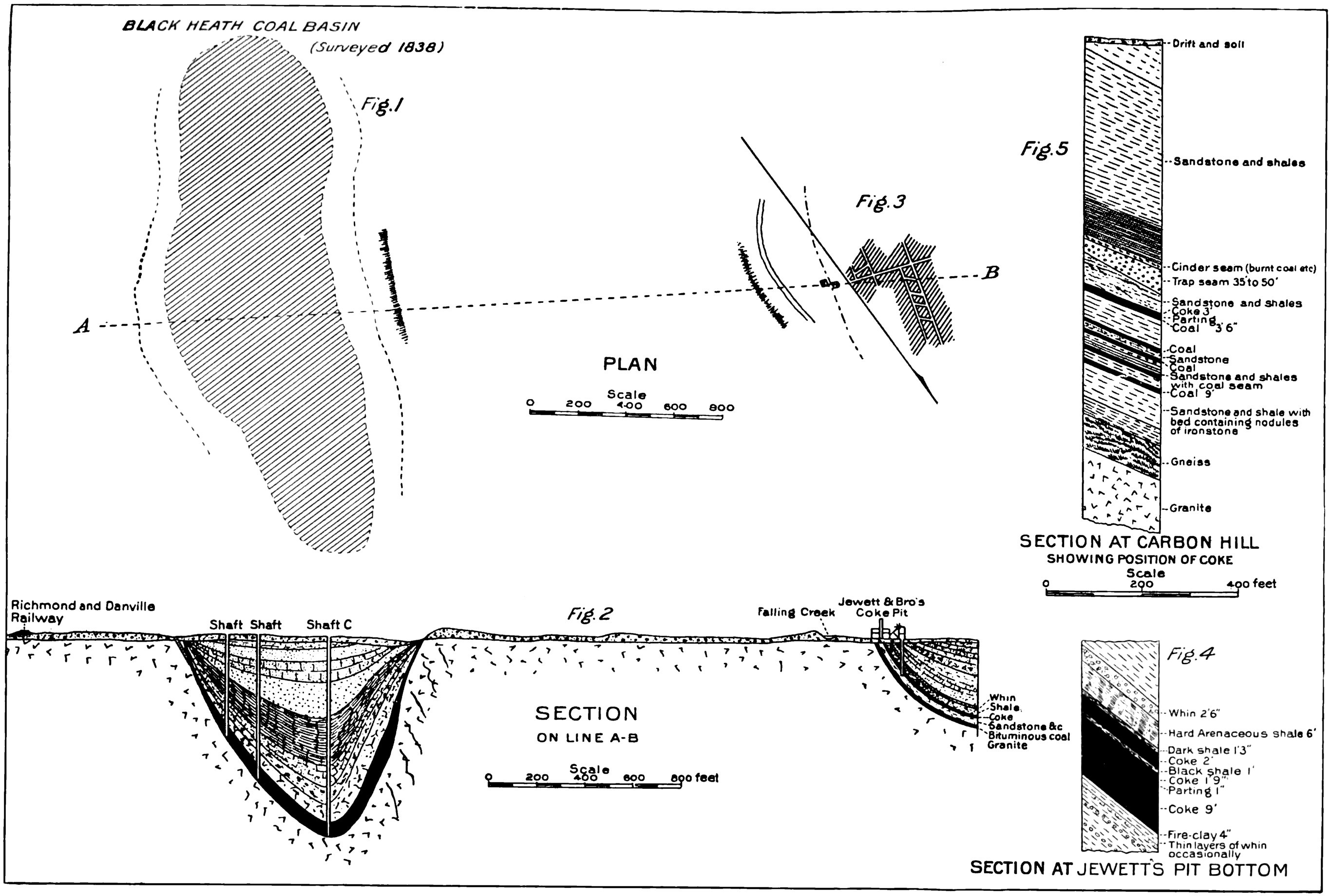
Plan and sections of old workings on eastern border of Richmond Basin
Summary edit
| Description |
English: Plate XXV from The Geology of the Richmond Basin published by USGS, which has the following caption: Plan and sections of old workings on eastern border, Richmond Basin. (After Clifford.) The text of the report refers to this figure as follows:
Later the report states:
|
| Date | |
| Source | Nathaniel Southgate Shaler and Jay Backus Woodworth, 1899. Geology of the Richmond Basin, Virginia. U.S. Government Printing Office. United States Geological Survey. |
| Author | USGS |
Licensing edit
This work is in the public domain in the United States because it is a work prepared by an officer or employee of the United States Government as part of that person’s official duties under the terms of Title 17, Chapter 1, Section 105 of the US Code.
Note: This only applies to original works of the Federal Government and not to the work of any individual U.S. state, territory, commonwealth, county, municipality, or any other subdivision. This template also does not apply to postage stamp designs published by the United States Postal Service since 1978. (See § 313.6(C)(1) of Compendium of U.S. Copyright Office Practices). It also does not apply to certain US coins; see The US Mint Terms of Use.
|
 | |
| This file has been identified as being free of known restrictions under copyright law, including all related and neighboring rights. | ||
File history
Click on a date/time to view the file as it appeared at that time.
| Date/Time | Thumbnail | Dimensions | User | Comment | |
|---|---|---|---|---|---|
| current | 19:28, 21 December 2022 | | 2,732 × 1,840 (707 KB) | Jstuby (talk | contribs) | Uploaded a work by USGS from Nathaniel Southgate Shaler and Jay Backus Woodworth, 1899. Geology of the Richmond Basin, Virginia. U.S. Government Printing Office. United States Geological Survey. with UploadWizard |
You cannot overwrite this file.
File usage on Commons
There are no pages that use this file.
File usage on other wikis
The following other wikis use this file:
- Usage on en.wikipedia.org