File:Germany topo Fulda Gap.jpg
No higher resolution available.
Germany_topo_Fulda_Gap.jpg (578 × 444 pixels, file size: 121 KB, MIME type: image/jpeg)
Captions
Captions
Add a one-line explanation of what this file represents
| Description |
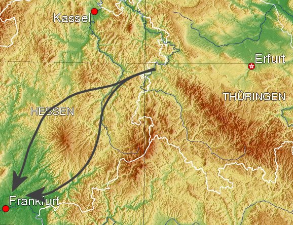
English: View of Germany. Arrows indicate theoretical vectors of attack via the Fulda Gap. Southern vector via town of Fulda, Northern via Bad Hersfeld, both are part of the Fulda Gap. |
||||||||||
| Date | 4 August 2006, 03:47 (UTC) | ||||||||||
| Source | Own derivative of Image:Germany topo.jpg | ||||||||||
| Author | Dual Freq | ||||||||||
| Permission (Reusing this file) |
|
||||||||||
| Other versions | Cropped version of Image:Germany topo.jpg |

File history
Click on a date/time to view the file as it appeared at that time.
| Date/Time | Thumbnail | Dimensions | User | Comment | |
|---|---|---|---|---|---|
| current | 03:47, 4 August 2006 | | 578 × 444 (121 KB) | Dual Freq (talk | contribs) | {{Information |Source=Own derivative of Image:Germany topo.jpg |Author=~~~ |other_versions=Cropped version of Image:Germany topo.jpg |Permission={{Bild-GFDL-GMT}} |Date=~~~~~ }} Category:Topographic maps |
You cannot overwrite this file.
File usage on Commons
The following page uses this file:
File usage on other wikis
The following other wikis use this file:
- Usage on de.wikipedia.org
- Usage on en.wikipedia.org
- Usage on es.wikipedia.org
- Usage on fi.wikipedia.org
- Usage on fr.wikipedia.org
- Usage on id.wikipedia.org
- Usage on it.wikipedia.org
- Usage on ja.wikipedia.org
- Usage on ko.wikipedia.org
- Usage on ru.wikipedia.org
- Usage on sv.wikipedia.org
- Usage on uk.wikipedia.org
- Usage on uz.wikipedia.org
- Usage on www.wikidata.org
- Usage on zh.wikipedia.org