File:Geroldsegg Schwarzenberg Panorama 1.jpg

Size of this preview: 800 × 207 pixels. Other resolutions: 320 × 83 pixels | 640 × 165 pixels | 1,024 × 264 pixels | 1,280 × 331 pixels | 7,221 × 1,865 pixels.
Original file (7,221 × 1,865 pixels, file size: 10.34 MB, MIME type: image/jpeg)
Captions
Captions
Add a one-line explanation of what this file represents
| Description |
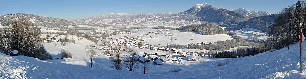
Deutsch: Panoramablick vom Hochälpelekopf kommend, auf Höhe Geroldsegg. In der Front liegt Schwarzenberg, dahinter die Gemeinde Egg und weiter hinten Lingenau. Der ansteigende Gebirgszug in der Bildmitte gehört zur Nagelfluhkette. Weiter rechts erhebt sich die Niedere zu deren Füßen der Ort Andelsbuch liegt. Am äusseren rechten Bildende befindet sich Bersbuch(ein Ortsteil von Andelsbuch). Am rechten Bildhorizont erheben sich unter anderem mit dem Hohen Ifen 2230m, Diedamskopf 2090m, Heiterberg, Großer Widderstein 2533m, Üntschenspitze 2135m, die ersten Gebirge der Nördlichen Kalkalpen in den Allgäuer Alpen.
|
||
| Date | |||
| Source | Own work | ||
| Author |
|
||
| Permission (Reusing this file) |
I, the copyright holder of this work, hereby publish it under the following licenses:
This file is licensed under the Creative Commons Attribution-Share Alike 3.0 Austria license.
 You may select the license of your choice. |


| Camera location | | View this and other nearby images on: OpenStreetMap |
|---|
File history
Click on a date/time to view the file as it appeared at that time.
| Date/Time | Thumbnail | Dimensions | User | Comment | |
|---|---|---|---|---|---|
| current | 22:05, 8 March 2013 | 7,221 × 1,865 (10.34 MB) | Böhringer (talk | contribs) | {{Information |Description= {{de|Panoramablick vom Hochälpelekopf kommend, auf Höhe Geroldsegg. In der Front liegt Schwarzenberg, dahinter die Gemeinde Egg und weiter... |
You cannot overwrite this file.
File usage on Commons
There are no pages that use this file.