File:Gleisplan Straßenbahn Frankfurt am Main.svg

Size of this PNG preview of this SVG file: 800 × 497 pixels. Other resolutions: 320 × 199 pixels | 640 × 397 pixels | 1,024 × 636 pixels | 1,280 × 795 pixels | 2,560 × 1,590 pixels | 1,900 × 1,180 pixels.
Original file (SVG file, nominally 1,900 × 1,180 pixels, file size: 90 KB)
Captions
Captions
Add a one-line explanation of what this file represents
Summary edit
| Description |
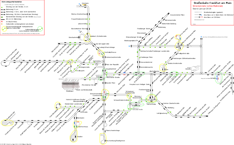
English: Track layout of Frankfurt Tramway. An interactive Version with projected tracks can be found at http://plan.frankfurtium.de/strassenbahnnetz.svg
Deutsch: Streckennetz der Straßenbahn Frankfurt am Main. Eine interaktive Version mit geplanten Strecken ist unter http://plan.frankfurtium.de/strassenbahnnetz.svg zu finden. |
| Date | |
| Source | Own work |
| Author | Baeuchle |
| Other versions | Gleisplan Straßenbahn Frankfurt am Main.png |
| SVG development | This map was created with an unknown SVG tool. |
Licensing edit
I, the copyright holder of this work, hereby publish it under the following licenses:

|
Permission is granted to copy, distribute and/or modify this document under the terms of the GNU Free Documentation License, Version 1.2 or any later version published by the Free Software Foundation; with no Invariant Sections, no Front-Cover Texts, and no Back-Cover Texts. A copy of the license is included in the section entitled GNU Free Documentation License. |
This file is licensed under the Creative Commons Attribution-Share Alike 4.0 International license.
- You are free:
- to share – to copy, distribute and transmit the work
- to remix – to adapt the work
- Under the following conditions:
- attribution – You must give appropriate credit, provide a link to the license, and indicate if changes were made. You may do so in any reasonable manner, but not in any way that suggests the licensor endorses you or your use.
- share alike – If you remix, transform, or build upon the material, you must distribute your contributions under the same or compatible license as the original.
You may select the license of your choice.
File history
Click on a date/time to view the file as it appeared at that time.
| Date/Time | Thumbnail | Dimensions | User | Comment | |
|---|---|---|---|---|---|
| current | 09:52, 6 January 2019 | | 1,900 × 1,180 (90 KB) | Baeuchle (talk | contribs) | - SVG-Fehler korrigiert - Haltestelle Bruchstraße - Haltestellengruppe Westbahnhof gelöscht: - Umstieg wird an Kuhwaldstraße nicht mehr angegeben - Im Gegensatz zu allen anderen Hstgrp sind diese Haltestellen nicht durch den Namen verbunden - Gleiswechsel Münzenbergerstraße hat kleineres × (sah so aus, als sei die ganze Strecke gesperrt) |
| 20:20, 17 December 2018 |  | 1,900 × 1,180 (97 KB) | Baeuchle (talk | contribs) | Reaktivierung Kleyestraße mit neuer Haltestelle "Gustavsburgplatz" und neue Haltestelle "Karmeliterkloster" in Innenstadt | |
| 13:51, 28 March 2016 |  | 1,900 × 1,180 (95 KB) | Baeuchle (talk | contribs) | Keine Aktuellen Umbauten; vorbereitung für Ringstraßenbahn | |
| 20:18, 17 December 2014 |  | 1,900 × 1,190 (84 KB) | Baeuchle (talk | contribs) | Strecke in Stresemannallee eröffnet, Update zu Umbauprojekten Zoo, Balduinstraße, Neu-Isenburg | |
| 16:51, 27 April 2014 |  | 1,900 × 1,190 (70 KB) | Baeuchle (talk | contribs) | Updates gemäß Entwicklung in der echten Welt: eingebautes Gleisdreieck Stresemannallee/Mörfelder Landstraße, abgekappter Lieschenstrecke (ist aber noch drin), Arthur-von-Weinberg-Steg und Lokalbahnhof wieder in Betrieb. | |
| 15:40, 10 March 2014 |  | 1,900 × 1,190 (71 KB) | Baeuchle (talk | contribs) | Barrierefreie Umbauten teilweise abgeschlossen | |
| 15:56, 19 October 2013 |  | 1,900 × 1,190 (72 KB) | Baeuchle (talk | contribs) | - Lokalbahnhof Bahnsteig Ri. Offenbach L15/16 verschoben; ist nicht im Bereich der Weiche - Balduinstraße: Ersatzhaltestelle angezeigt - Flaschenburger Straße und - Wiener Straße: Haltestelle Ri. Offenbach ist von Bürgersteig aus,... | |
| 08:36, 5 October 2013 |  | 1,900 × 1,190 (68 KB) | Baeuchle (talk | contribs) | Kleine Korrekturen, neuer Gleiswechsel in Oberrad. | |
| 21:51, 29 December 2011 |  | 1,900 × 1,190 (63 KB) | Baeuchle (talk | contribs) | {{Information |Description ={{en|1=Track layout of Frankfurt Tramway. Bases on png by User:Philipp Gross}} {{de|1=Streckennetz der Straßenbahn Frankfurt am Main. Größtenteils basierend auf png von User:Philipp Gross}} |Source ={{own}} |Autho |
You cannot overwrite this file.
File usage on Commons
The following 14 pages use this file:
- User:Chumwa/OgreBot/Potential transport maps/2016 March 21-31
- User:Chumwa/OgreBot/Potential transport maps/2018 December 11-20
- User:Chumwa/OgreBot/Potential transport maps/2019 January 1-10
- User:Chumwa/OgreBot/Public transport information/2016 March 21-31
- User:Chumwa/OgreBot/Public transport information/2018 December 11-20
- User:Chumwa/OgreBot/Public transport information/2019 January 1-10
- User:Chumwa/OgreBot/Transport Maps/2016 March 21-31
- User:Chumwa/OgreBot/Transport Maps/2018 December 11-20
- User:Chumwa/OgreBot/Transport Maps/2019 January 1-10
- User:Chumwa/OgreBot/Travel and communication maps/2016 March 21-31
- User:Chumwa/OgreBot/Travel and communication maps/2018 December 11-20
- User:Chumwa/OgreBot/Travel and communication maps/2019 January 1-10
- User:Nordlicht8/Rail Germany/2016 March 21-31
- File:Gleisplan Straßenbahn Frankfurt am Main.png
File usage on other wikis
The following other wikis use this file:
- Usage on de.wikipedia.org