File:Glencoe Water Fall - geograph.org.uk - 840889.jpg
Size of this preview: 630 × 599 pixels. Other resolutions: 252 × 240 pixels | 504 × 480 pixels | 640 × 609 pixels.
Original file (640 × 609 pixels, file size: 179 KB, MIME type: image/jpeg)
Captions
Captions
Add a one-line explanation of what this file represents
Summary edit
| Description |
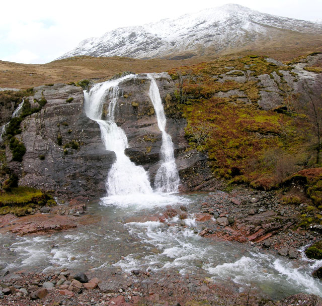
English: Glencoe Water Fall This very dangerous bend in the road through Glencoe, combined with tourist interest in this water fall must have forced the local authorities to recently build a Lay-by that can hold about five cars. They did not stop there. They built an overhanging viewpoint to ensure that your photo of the falls looks identical to ever other photo taken from that spot. If you are driving through Glencoe after a period of prolonged rain, this is a must-get photograph. If it has been a dry period then just carry on and get yer photo taken beside the bagpiper at the Three Sisters. |
| Date | |
| Source | From geograph.org.uk |
| Author | Nigel J C Turnbull |
| Attribution (required by the license) | Nigel J C Turnbull / Glencoe Water Fall / |
| Camera location | | View this and other nearby images on: OpenStreetMap |
|---|
_heading:157.00&language=en)
| Object location | | View this and other nearby images on: OpenStreetMap |
|---|
_heading:157.00&language=en)
Licensing edit

|
This image was taken from the Geograph project collection. See this photograph's page on the Geograph website for the photographer's contact details. The copyright on this image is owned by Nigel J C Turnbull and is licensed for reuse under the Creative Commons Attribution-ShareAlike 2.0 license.
|
This file is licensed under the Creative Commons Attribution-Share Alike 2.0 Generic license.
Attribution: Nigel J C Turnbull
- You are free:
- to share – to copy, distribute and transmit the work
- to remix – to adapt the work
- Under the following conditions:
- attribution – You must give appropriate credit, provide a link to the license, and indicate if changes were made. You may do so in any reasonable manner, but not in any way that suggests the licensor endorses you or your use.
- share alike – If you remix, transform, or build upon the material, you must distribute your contributions under the same or compatible license as the original.
File history
Click on a date/time to view the file as it appeared at that time.
| Date/Time | Thumbnail | Dimensions | User | Comment | |
|---|---|---|---|---|---|
| current | 23:01, 20 February 2011 | | 640 × 609 (179 KB) | GeographBot (talk | contribs) | == {{int:filedesc}} == {{Information |description={{en|1=Glencoe Water Fall This very dangerous bend in the road through Glencoe, combined with tourist interest in this water fall must have forced the local authorities to recently build a Lay-by that can |
You cannot overwrite this file.
File usage on Commons
There are no pages that use this file.