File:Granice 1921 slask 1.png

Size of this preview: 360 × 599 pixels. Other resolutions: 144 × 240 pixels | 288 × 480 pixels | 462 × 768 pixels | 616 × 1,024 pixels | 1,852 × 3,080 pixels.
Original file (1,852 × 3,080 pixels, file size: 1.84 MB, MIME type: image/png)
Captions
Captions
Add a one-line explanation of what this file represents
| Description |
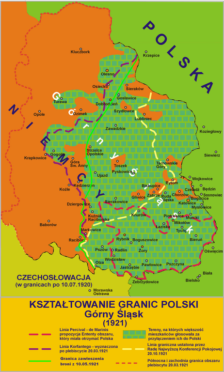
Polski: Kształtowanie granic Polski - Górny Śląski - (1921) |
||
| Date |
I, the copyright holder of this work, hereby publish it under the following licenses:
This file is licensed under the Creative Commons Attribution-Share Alike 4.0 International, 3.0 Unported, 2.5 Generic, 2.0 Generic and 1.0 Generic license.
You may select the license of your choice. |
||
| Source | J. J. Tazbir Wielki Atlas Historyczny, Demart, Warszawa, 2008 | ||
| Author | Lonio17 |

File history
Click on a date/time to view the file as it appeared at that time.
| Date/Time | Thumbnail | Dimensions | User | Comment | |
|---|---|---|---|---|---|
| current | 21:15, 8 August 2011 | | 1,852 × 3,080 (1.84 MB) | Mixx321 (talk | contribs) | Linia zawieszenia broni na podstawie Iwaszkiewicz Witold, "''Trzecie powstanie śląskie - zwycięski remis''", Mówią Wieki nr specjalny 1/2011, wyd. Bellona SA, ISSN 18978088. |
| 11:17, 28 October 2010 |  | 1,852 × 3,080 (1.7 MB) | Lonio17 (talk | contribs) | {{Information |Description={{pl|1=Kształtowanie granic Polski - Górny Śląski - (1921)}} |Source=J. J. Tazbir ''Wielki Atlas Historyczny'', Demart, Warszawa, 2008 |Author=Lonio17 |Date=2010-10-28 {{self|GFDL|cc-by-sa-all}} [[Category: | |
| 07:15, 23 October 2010 |  | 1,852 × 3,080 (1.7 MB) | Lonio17 (talk | contribs) | {{Information |Description={{pl|1=Kształtowanie granic Polski - Górny Śląski - (1921)}} |Source=J. J. Tazbir ''Wielki Atlas Historyczny'', Demart, Warszawa, 2008 |Author=Lonio17 |Date=2010-10-23 {{self|GFDL|cc-by-sa-all}} [[Category: | |
| 11:45, 22 October 2010 |  | 1,852 × 3,080 (1.71 MB) | Lonio17 (talk | contribs) | {{Information |Description={{pl|1=Kształtowanie granic Polski - Górny Śląski - (1921)}} |Source=J. J. Tazbir ''Wielki Atlas Historyczny'', Demart, Warszawa, 2008 |Author=Lonio17 |Date=2010-10-22 {{self|GFDL|cc-by-sa-all}} [[Category: | |
| 14:29, 26 September 2010 |  | 1,864 × 2,975 (1.81 MB) | Lonio17 (talk | contribs) | {{Information |Description={{pl|1=Kształtowanie granic Polski - Górny Śląski - (1921)}} |Source={{own}}J. J. Tazbir ''Wielki Atlas Historyczny'', Demart, Warszawa, 2008 |Author=Lonio17 |Date=2010-09-26 {{self|GFDL|cc-by-sa-all}} [[Ca |
You cannot overwrite this file.
File usage on Commons
The following page uses this file:
File usage on other wikis
The following other wikis use this file:
- Usage on cs.wikipedia.org
- Usage on eo.wikipedia.org
- Usage on pl.wikipedia.org