File:Great Lakes (metric DE).svg

Size of this PNG preview of this SVG file: 800 × 320 pixels. Other resolutions: 320 × 128 pixels | 640 × 256 pixels | 1,024 × 409 pixels | 1,280 × 512 pixels | 2,560 × 1,023 pixels | 1,201 × 480 pixels.
Original file (SVG file, nominally 1,201 × 480 pixels, file size: 25 KB)
Captions
Captions
Add a one-line explanation of what this file represents
Summary edit
.svg&action=edit§ion=1)
| Description |
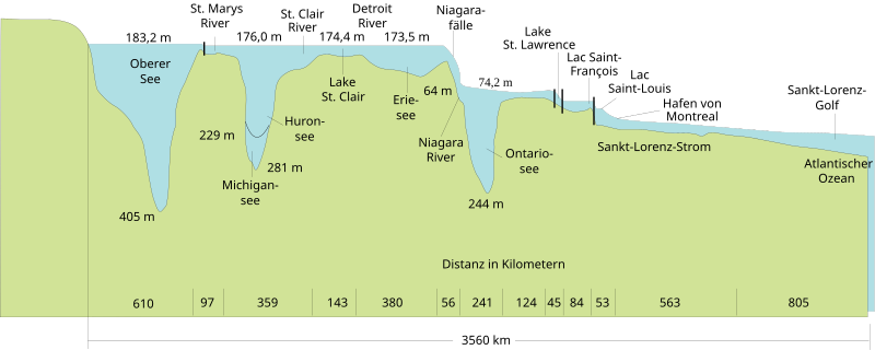
English: The figure shows typical water surface elevations and comparative lake depths of the Great Lakes with geographic Names in German and dimensions in the metric system. Deutsch: Die Abbildung zeigt die typischen Höhenangaben der Wasseroberflächen und vergleichsweise Wassertiefen der Großen Seen. |
| Date | |
| Source |
This file was derived from: Great Lakes.svg: |
| Author |
Great Lakes.svg: U.S. Army Corps of Engineers, Detroit District |
| SVG development | This map was created with Adobe Illustrator, edited with Inkscape. |
Licensing edit
.svg&action=edit§ion=2)
This work is in the public domain in the United States because it is a work prepared by an officer or employee of the United States Government as part of that person’s official duties under the terms of Title 17, Chapter 1, Section 105 of the US Code.
Note: This only applies to original works of the Federal Government and not to the work of any individual U.S. state, territory, commonwealth, county, municipality, or any other subdivision. This template also does not apply to postage stamp designs published by the United States Postal Service since 1978. (See § 313.6(C)(1) of Compendium of U.S. Copyright Office Practices). It also does not apply to certain US coins; see The US Mint Terms of Use.
|
 | |
| This file has been identified as being free of known restrictions under copyright law, including all related and neighboring rights. | ||
File history
Click on a date/time to view the file as it appeared at that time.
| Date/Time | Thumbnail | Dimensions | User | Comment | |
|---|---|---|---|---|---|
| current | 21:34, 11 October 2017 | 1,201 × 480 (25 KB) | Furfur (talk | contribs) | grafische Details, Bild etwas skaliert | |
| 14:50, 18 May 2017 | 1,000 × 399 (25 KB) | Railway Maps (talk | contribs) | Atlantic Ocean -> Atlantischer Ozean | ||
| 06:40, 14 January 2015 | 1,000 × 399 (25 KB) | Wereldburger758 (talk | contribs) | Removal flowroot (blackbox). Valid SVG now. | ||
| 18:11, 29 November 2014 | 1,000 × 399 (30 KB) | Mightyscoopa (talk | contribs) | replaced broken text box "Ontario-/n see" | ||
| 18:04, 29 November 2014 | 1,000 × 399 (30 KB) | Mightyscoopa (talk | contribs) | User created page with UploadWizard |
You cannot overwrite this file.
File usage on Commons
There are no pages that use this file.
File usage on other wikis
The following other wikis use this file:
- Usage on de.wikipedia.org
- Usage on frr.wikipedia.org
.svg&oldid=796566241)