File:Great Map of Japan WDL9930.png

Size of this preview: 800 × 572 pixels. Other resolutions: 320 × 229 pixels | 640 × 457 pixels | 1,024 × 732 pixels | 1,280 × 915 pixels | 1,433 × 1,024 pixels.
Original file (1,433 × 1,024 pixels, file size: 2.74 MB, MIME type: image/png)
Captions
Captions
Add a one-line explanation of what this file represents
Summary edit
| Author |
Русский: Нагакубо, Секисуи, 1717—1801 гг.
Français : Nagakubo Sekisui, 1717-1801
English: Nagakubo, Sekisui, 1717-1801
中文:长久保赤水,1717-1801 年
Português: Nagakubo, Sekisui, 1717-1801
العربية: ناغاكوبو سكيسوي، 1717-1801
Español: Nagakubo, Sekisui, 1717-1801 |
| Title |
Русский: Большая карта Японии
Français : Grande carte du Japon
English: Great Map of Japan
中文:大日本全图
Português: Mapa grande do Japão
العربية: الخريطة الكبرى لليابان
Español: Gran mapa de Japón |
| Description |
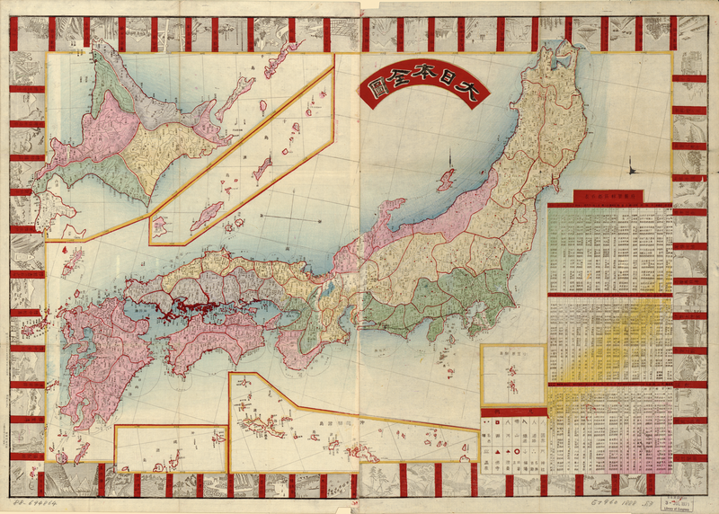
Русский: Эта карта Японии является копией карты, впервые напечатанной в 1779 г. Нагакубо Секисуи (1717—1801 гг.), на которой впервые были отмечены параллели и меридианы. Замеры позволили сделать более точное географическое изображение по сравнению с предыдущими богато иллюстрированными картами. Карта имела коммерческий успех и была много раз перепечатана и скопирована в эпоху Мейдзи (1868—1912 гг.). В этом экземпляре на полях помечены основные достопримечательности, в том числе храмы и места поклонения, старые замки и живописные пейзажи. Кроме того, отмечены основные дороги и расстояния морских путей, а также таблица gun (уездов) справа внизу. На пяти вставках изображены различные группы японских островов.
Français : Cette carte du Japon, qui est une réplique d'une carte publiée en premier lieu en 1779 par Nagakubo Sekisui (1717–1801), fut la première en son genre à inclure les latitudes et les longitudes. Les mesures permettent une représentation géographique plus précise que les cartes picturales ornées antérieures. Constituant un succès commercial, elle fut réimprimée et imitée à de nombreuses reprises au cours de l'ère Meiji (1868–1912). Cette carte inclut les points d'intérêt majeurs dans les marges, notamment les temples et les sanctuaires, les anciens châteaux et les paysages pittoresques. Elle indique également les principales artères et les distances des routes maritimes. En bas à droite, un tableau répertorie les gun (districts). Les différents groupes d'îles du Japon sont insérés dans cinq cartouches.
English: This map of Japan is a replica of a map that was first published in 1779 by Nagakubo Sekisui (1717–1801), the first of its kind to include latitude and longitude lines. The measurements allowed for a more accurate geographic representation than previous ornate pictorial maps. It was a commercial success and was reprinted and imitated numerous times into the Meiji era (1868–1912). This map includes major points of interest on the margins, including temples and shrines, old castles, and scenic landscapes. It also notes major thoroughfares and distances of sea routes, as well as a table of gun (districts) on the lower right. Five insets depict Japan’s various island groups.
中文:这幅日本地图是长久保赤水(Nagakubo Sekisui,1717-1801 年)于 1779 年首次出版的地图的副本,他首开先河,将经度线和纬度线纳入地图中。 与之前装饰华丽的地图相比,加上经度线和纬度线的地图可以更精确地展示地理位置。 这幅地图在商业上获得成功,在明治时代(1868–1912 年)之前被数次重印和仿制。 地图的边缘处介绍了主要景点,包括寺庙和神社、古老的城堡和优美的景观。 地图上还标出了主要街道和海上航线的距离,右下角有一份地区列表。 五幅插图描绘了日本的各个岛屿群。
Português: Este mapa do Japão é uma réplica de um mapa que foi publicado pela primeira vez em 1779 por Nagakubo Sekisui (1717–1801), o primeiro de seu tipo a incluir linhas de latitude e longitude. As medidas permitiam uma representação geográfica mais precisa do que os mapas figurativos ornamentados de antes. Ele foi um sucesso comercial e foi reimpresso e copiado várias vezes até a era Meiji (1868–1912). Este mapa inclui os principais pontos de interesse nas margens, como templos e santuários, castelos antigos e paisagens cênicas. Traz ainda as principais vias públicas e distâncias de rotas marítimas, bem como uma tabela de gun (distritos) na parte inferior direita. Cinco inserções relatam os vários grupos de ilhas do Japão.
العربية: تُعد خريطة اليابان هذه نسخة طبق الأصل من خريطة نشرها ناغاكوبو سكيسوي (1717-1801) لأول مرة في 1779، وهي أول خريطة توضح خطوط العرض والطول. ساعدت القياسات على خلق تمثيل جغرافي أكثر دقة عن سابقتها من الخرائط التصويرية المزخرفة. وحققت الخريطة نجاحاً تجارياً وأُعيدت طباعتها ومحاكاتها عدة مرات في عصر مييغي (1868-1912). تُوضح هوامش هذه الخريطة المعالم الرئيسية للدولة، والتي تشمل معابد وأضرحة وقلاعاً قديمة ومناظر طبيعية خلابة. كما تُظهر الممرات المائية وأطوال الطرق البحرية الرئيسية، إضافة إلى جدول غون (للمقاطعات) أسفل اليمين. هناك خمس مجموعات خرائط مُدرَجة تُمثل مجموعات الجزر المختلفة باليابان.
Español: Este mapa de Japón es una reproducción de un mapa de Nagakubo Sekisui (1717-1801) que se publicó por primera vez en 1779: el primero de este tipo que incluyó líneas de latitud y longitud. Las mediciones permitieron una representación geográfica más precisa que los anteriores mapas pictóricos ornamentales. Fue un éxito comercial y se reimprimió e imitó en numerosas ocasiones en la era Meiji (1868-1912). Este mapa tiene los principales puntos de interés en los márgenes, como templos y santuarios, castillos antiguos y paisajes pintorescos. También indica las principales avenidas y las distancias de las rutas marítimas, así como un cuadro de los gun (distritos), abajo a la derecha. Hay cinco recuadros que representan los diversos grupos insulares de Japón. |
| Date | 1888 |
| Medium |
Русский: Карты
Français : Cartes
English: Maps
中文:地图
Português: Mapas
العربية: خرائط
Español: Mapas |
| Dimensions |
English: 1 map : color ; 50 x 73 centimeters folded in cover 18 x 10 centimeters. |
| Collection |
Русский: Библиотека Конгресса
Français : Bibliothèque du Congrès
English: Library of Congress
中文:国会图书馆
Português: Biblioteca do Congresso
العربية: مكتبة الكونغرس
Español: Biblioteca del Congreso |
| Place of creation |
Русский: Япония
Français : Japon
English: Japan
中文:日本
Português: Japão
العربية: اليابان
Español: Japón |
| Notes |
Original language title: 大日本全圖 Русский: Масштаб прим. 1:2 500 000.
Français : Échelle 1:2 500 000 env.
English: Scale ca. 1:2,500,000.
中文:比例尺约为: 1:2,500,000.
Português: Escala aprox. 1:2.500.000.
العربية: مقياس الرسم حوالي 1:2,500,000.
Español: Escala ca. 1:2 500 000. |
| References | http://hdl.loc.gov/loc.wdl/dlc.9930 |
| Source/Photographer |
|
Licensing edit
|
This is a faithful photographic reproduction of a two-dimensional, public domain work of art. The work of art itself is in the public domain for the following reason:
The official position taken by the Wikimedia Foundation is that "faithful reproductions of two-dimensional public domain works of art are public domain".
This photographic reproduction is therefore also considered to be in the public domain in the United States. In other jurisdictions, re-use of this content may be restricted; see Reuse of PD-Art photographs for details. | ||||
File history
Click on a date/time to view the file as it appeared at that time.
| Date/Time | Thumbnail | Dimensions | User | Comment | |
|---|---|---|---|---|---|
| current | 05:19, 12 March 2014 | | 1,433 × 1,024 (2.74 MB) | Fæ (talk | contribs) | =={{int:filedesc}}== {{Artwork |artist = |author ={{ru|1=Нагакубо, Секисуи, 1717—1801 гг.}} {{fr|1=Nagakubo Sekisui, 1717-1801}} {{en|1=Nagakubo, Sekisui, 1717-1801}} {{zh|1=长久保赤水,1717-1801 年}} {{pt|1=Nagakubo, Sekisui... |
You cannot overwrite this file.
File usage on Commons
The following page uses this file:
File usage on other wikis
The following other wikis use this file:
- Usage on de.wikipedia.org
- Usage on fr.wikipedia.org