File:Great Rift Valley, Kenya ESA22084759.tiff

Original file (7,141 × 9,817 pixels, file size: 200.59 MB, MIME type: image/tiff)
Captions
Captions
Summary edit
| Description |
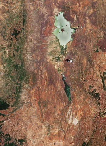
English: The Copernicus Sentinel-2 mission takes us over part of the Great Rift Valley, Kenya. This valley is part of the Gregory Rift, an eastern branch of the East African Rift, which is being caused by the separation of the Somali plate from the Nubian plate. Major tectonic and volcanic activity have shaped the distinctive landscape of the Great Rift Valley which runs through Kenya from north to south. The dramatic landscape contains the Cherangani Hills and forests to the west, a chain of volcanoes, of which some are still active, escarpments and jewel-like lakes. Lake Baringo, one of the most northern of the Kenyan Rift Valley lakes, is visible at the top of the image. With a surface area of 130 sq km and an elevation of around 970 m, the lake has an average depth of around 5 m and it is one of the two freshwater lakes in the Rift Valley – the other being Lake Naivasha (not visible). This lake has no visible outlet; its waters are thought to seep into lavas at its northern end – where the rocky shore contrasts with the alluvial flat on its southern border. Baringo is dotted with several small islands. Its largest is visible in the centre of the lake and is called Ol Kokwe (also known as the Meeting Place). It is an extinct volcano with several hot springs. A great variety of birds inhabit Lake Baringo, which is also home to hippopotamuses and crocodiles. South of Lake Baringo lies Lake Bogoria – a saline, alkaline lake. The long and narrow lake has an area of around 30 sq km and is around 10 m deep. Lake Bogoria provides refuge for the lesser flamingo, with a population of around 1 to 1.5 million, and also supports more than 300 waterbird species. The lake is a designated Ramsar site and is also part of the Lake Bogoria National Reserve. The lake is famous for geysers and hot springs along the bank of the lake – some of which can erupt up to 5 m high. The lake’s stable water level makes it highly important during times of drought. Copernicus Sentinel-2 is a two-satellite mission to supply the coverage and data delivery needed for Europe’s Copernicus programme. The mission’s frequent revisits over the same area and high spatial resolution allow changes in inland water bodies to be closely monitored. This image, captured on 13 March 2019, is also featured on the Earth from Space video programme. |
| Date | Taken on 13 March 2019 |
| Source | Great Rift Valley, Kenya |
| Author | European Space Agency |
| Other versions |
|
| Activity | Observing the Earth |
| Mission | Sentinel-2 |
| Set | Earth observation image of the week |
| System | Copernicus |

Licensing edit

|
This image contains data from a satellite in the Copernicus Programme, such as Sentinel-1, Sentinel-2 or Sentinel-3. Attribution is required when using this image.
Attribution: Contains modified Copernicus Sentinel data 2019
The use of Copernicus Sentinel Data is regulated under EU law (Commission Delegated Regulation (EU) No 1159/2013 and Regulation (EU) No 377/2014). Relevant excerpts:
Free access shall be given to GMES dedicated data [...] made available through GMES dissemination platforms [...].
Access to GMES dedicated data [...] shall be given for the purpose of the following use in so far as it is lawful:
GMES dedicated data [...] may be used worldwide without limitations in time.
GMES dedicated data and GMES service information are provided to users without any express or implied warranty, including as regards quality and suitability for any purpose. |
This media was created by the European Space Agency (ESA).
Where expressly so stated, images or videos are covered by the Creative Commons Attribution-ShareAlike 3.0 IGO (CC BY-SA 3.0 IGO) licence, ESA being an Intergovernmental Organisation (IGO), as defined by the CC BY-SA 3.0 IGO licence. The user is allowed under the terms and conditions of the CC BY-SA 3.0 IGO license to Reproduce, Distribute and Publicly Perform the ESA images and videos released under CC BY-SA 3.0 IGO licence and the Adaptations thereof, without further explicit permission being necessary, for as long as the user complies with the conditions and restrictions set forth in the CC BY-SA 3.0 IGO licence, these including that:
See the ESA Creative Commons copyright notice for complete information, and this article for additional details.
|
 | |
This file is licensed under the Creative Commons Attribution-ShareAlike 3.0 IGO license. Attribution: ESA, CC BY-SA IGO 3.0
| ||
File history
Click on a date/time to view the file as it appeared at that time.
| Date/Time | Thumbnail | Dimensions | User | Comment | |
|---|---|---|---|---|---|
| current | 17:45, 19 June 2020 |  | 7,141 × 9,817 (200.59 MB) | OptimusPrimeBot (talk | contribs) | #Spacemedia - Upload of https://esamultimedia.esa.int/img/2020/06/Lake_Bogoria_Sentinel-2A_MSIL2A_13March2019_432_MM.tif via Commons:Spacemedia |
You cannot overwrite this file.
File usage on Commons
The following page uses this file: