File:Great Schism 1054 with former borders-ar.png

Size of this preview: 560 × 599 pixels. Other resolutions: 224 × 240 pixels | 448 × 480 pixels | 717 × 768 pixels | 957 × 1,024 pixels | 2,000 × 2,141 pixels.
Original file (2,000 × 2,141 pixels, file size: 543 KB, MIME type: image/png)
Captions
Captions
Add a one-line explanation of what this file represents
Summary edit
| Description |
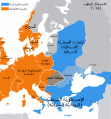
العربية: خارطة تُظهر انقسام الدول والأمم بين الكنيستين الشرقيَّة والغربيَّة سنة 1054، كما وتظهر فيها حدود تلك الدول السابقة. |
| Date | (UTC) |
| Source |
This file was derived from: Great Schism 1054 with former borders.png:  |
| Author |
|
| This is a retouched picture, which means that it has been digitally altered from its original version. Modifications: translated to Arabic - عُرِّبت. The original can be viewed here: Great Schism 1054 with former borders.png:
|
Licensing edit
I, the copyright holder of this work, hereby publish it under the following license:
| I, the copyright holder of this work, release this work into the public domain. This applies worldwide. In some countries this may not be legally possible; if so: I grant anyone the right to use this work for any purpose, without any conditions, unless such conditions are required by law. |
Original upload log edit
This image is a derivative work of the following images:
- File:Great_Schism_1054_with_former_borders.png licensed with PD-self
- 2011-10-28T13:31:27Z Iaaasi 2000x2141 (548099 Bytes) smaller Orthodox area
- 2011-10-28T13:30:51Z Iaaasi 2000x2141 (548099 Bytes) smaller Orthodox area
- 2011-10-26T16:18:45Z Iaaasi 2000x2141 (617584 Bytes) rv original research
- 2011-10-26T15:53:03Z CoolKoon 2000x2141 (429711 Bytes) Part of the map has been redrawn to represent a more precise interpretation of the information from the Serbian map. This new version is much more factual as well.
- 2011-10-07T07:49:07Z Iaaasi 2000x2141 (617584 Bytes) the map is sourced. there are different theories
- 2011-10-06T20:14:57Z CoolKoon 2000x2141 (541793 Bytes) Reverted to version as of 15:48, 3 October 2011 - This version's REALLY closer to the truth and besides, Orthodox church was NEVER dominant in 75% of KoH as suggested by the new map.
- 2011-10-03T19:03:35Z Iaaasi 2000x2141 (617584 Bytes) Reverted to version as of 12:22, 18 September 2011
- 2011-10-03T15:48:46Z Iaaasi 2000x2141 (541793 Bytes) Reverted to version as of 13:55, 18 September 2011
- 2011-10-03T11:05:45Z Iaaasi 2000x2141 (617584 Bytes) see talk page
- 2011-09-18T13:55:15Z Bencmq 2000x2141 (541793 Bytes) Reverted to version as of 19:53, 21 March 2011, last version before dispute
- 2011-09-18T12:22:08Z Iaaasi 2000x2141 (617584 Bytes) sourced changed: Orthodox Vlachs were in Wllachia and Transylvania
- 2011-09-17T23:43:51Z Fakirbakir 2000x2141 (541793 Bytes) Reverted to version as of 21:54, 15 September 2011 The majority of the sources was disregarded, please see talk page (debate)
- 2011-09-15T22:14:38Z Iaaasi 2000x2141 (617584 Bytes) sourced change, I've sent you the scanned page from the historical atlas on your e-mail
- 2011-09-15T21:54:17Z Fakirbakir 2000x2141 (541793 Bytes) Reverted to version as of 16:27, 13 September 2011 Do not modify it , your sources are unreliable
- 2011-09-13T19:51:16Z Iaaasi 2000x2141 (617584 Bytes) Reverted to version as of 21:22, 11 September 2011
- 2011-09-13T16:27:33Z Fakirbakir 2000x2141 (541793 Bytes) Reverted to version as of 19:53, 21 March 2011 See talk page debate
- 2011-09-11T21:22:00Z Iaaasi 2000x2141 (617584 Bytes) correct religious structure of Hungary, more on talk page
- 2011-09-11T21:21:30Z Iaaasi 2000x2141 (617584 Bytes) correct religious structure of Hungary
- 2011-03-21T19:53:42Z Tobi85 2000x2141 (541793 Bytes) Reverted to version as of 19:48, 21 March 2011
- 2011-03-21T19:49:58Z Tobi85 2000x2141 (661999 Bytes) Reverted to version as of 00:59, 14 March 2011
- 2011-03-21T19:49:15Z Tobi85 2000x2141 (644209 Bytes) Reverted to version as of 06:56, 17 March 2011
- 2011-03-21T19:48:31Z Tobi85 2000x2141 (541793 Bytes) Please do not falsify the source of this map, create and upload your own map
- 2011-03-17T06:56:17Z J intela 2000x2141 (644209 Bytes) I'm now sure it was eastern orthidox.
- 2011-03-14T02:08:05Z J intela 2000x2141 (660612 Bytes) Fixed border of Moldovia.
- 2011-03-14T00:59:18Z J intela 2000x2141 (661999 Bytes) I'm Pretty sure romania was some sort of christian even if it wasn't under control of a state. I also Indicated some orthodox preasance in transylivania, relavent to the debate.
- 2011-01-18T11:33:12Z Fakirbakir 2000x2141 (541793 Bytes) Orthodox churches (Byzantine Churches) were spread sporadically in the eleventh century in Hungary. Source: Dora Wiebenson, József Sisa, Pál Lövei, The architecture of historic Hungary, p. 11.
- 2010-12-26T19:51:34Z Qorilla 2000x2141 (569008 Bytes) Pechenegs name corrected
- 2010-11-10T22:07:33Z Fakirbakir 2000x2141 (550062 Bytes) We can assume Greek-Orthodox presence in Kingdom of Hungary in the 11th century.(See talk page)
- 2010-11-07T18:15:20Z Fakirbakir 2000x2141 (522344 Bytes) Armenia, Calabria, Apulia are repaired
- 2010-11-07T10:30:27Z Fakirbakir 2000x2141 (521327 Bytes) Better quality.
- 2010-11-06T12:34:50Z Fakirbakir 560x599 (130687 Bytes) I've tried to fix it up, Old Prussians were not Christian, Teutonic state has not been founded yet,blue and gray areas in eastern Baltic run straighter See:http://en.wikipedia.org/wiki/Talk:Central_Europe
- 2010-10-02T15:57:41Z Er-vet-en 560x599 (166829 Bytes)
- 2010-09-04T17:13:57Z Tobi85 2000x2141 (546867 Bytes) {{Information |Description={{en|1=The map of the eastern/western allegiances in 1054 with the former country borders.}} {{de|1=Karte über das [[:de:Morgenländisches Schisma|Morgenländische Schisma]] mit den ehemaligen Land
Uploaded with derivativeFX
File history
Click on a date/time to view the file as it appeared at that time.
| Date/Time | Thumbnail | Dimensions | User | Comment | |
|---|---|---|---|---|---|
| current | 16:41, 5 November 2012 | | 2,000 × 2,141 (543 KB) | باسم (talk | contribs) | == {{int:filedesc}} == {{Information |Description={{ar|1=خارطة تُظهر انقسام الدول والأمم بين الكنيستين الشرقيَّة والغربيَّة سنة 1054، كما وتظهر فيها حدود تلك الدول ا... |
You cannot overwrite this file.
File usage on Commons
There are no pages that use this file.
File usage on other wikis
The following other wikis use this file:
- Usage on ar.wikipedia.org
- Usage on arz.wikipedia.org
- Usage on ms.wikipedia.org