File:GreeceNaturalGasPipelinesApproximation.png
No higher resolution available.
GreeceNaturalGasPipelinesApproximation.png (496 × 496 pixels, file size: 194 KB, MIME type: image/png)
Captions
Captions
Add a one-line explanation of what this file represents
| Description |
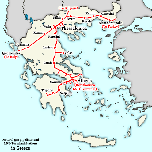
English: A map showing the approximate locations of natural gas pipelines in Greece]]: they run approximately from Alexandroupolis to Thessaloniki and then fork into two directions, one going towards Igoumenitsa (and later Italy) and the other towards Larissa, Lamia, Thiva, Athens, Corinth, Nauplio, and Tripolis. Note: this map also shows the planned Greece-Italy pipeline from Thessaloniki to Igoumenitsa which is not built yet. Greece maintains a powerful energy industry with particular emphasis on natural gas, managed by the DEPA company. This map is an approximation of the natural gas pipelines in Greece, based on information available from http://www.depa.gr/files/downloadables/national-map-gr.pdf
Ελληνικά: Ένας χάρτης που δείχνει στο περίπου τις τοποθεσίες αγωγών φυσικού αερίου της Ελλάδος: τρέχουν από Αλεξανδρούπολη προς Θεσσαλονικη και μετά χωρίζονται σε δυο δρόμους, ένα προς Ιγουμενίτσα (και τελικά Ιταλία) και τον άλλο προς Λάρισα, Λαμία, Θήβα, Αθήνα, Κόρινθος, και Τρίπολη. Σημείωση: ο χάρτης δείχνει και τον αγωγό Ιταλίας-Ελλάδας από Θεσσαλονίκη έως Ιγουμενίτσα που δεν έχει χτιστεί ακόμη. Η Ελλάδα διαθέτει μία παντοδύναμη ενεργειακή οικονομία με ιδιαίτερη έμφαση στο φυσικό αέριο, το οποίο τελεί υπό την διαχείρηση της εταιρείας ΔΕΠΑ. Αυτός ο χάρτης είναι μία ανακριβή απεικόνιση των σωλήνων φυσικού αερίου της Ελλάδος, βασισμένος σε πληροφορίες που υπάρχουν στο http://www.depa.gr/files/downloadables/national-map-gr.pdf |
| Date | |
| Source | Derivative work based on http://commons.wikimedia.org/wiki/File:Greece_outline_map.png |
| Author | This derivative work is from NSK Nikolaos S. Karastathis (User:NSK Nikolaos S. Karastathis); the original work upon this derivative work is based on was originally uploaded by ChrisO at en.wikipedia ( http://en.wikipedia.org/wiki/User:ChrisO ) and it was later uploaded on Wikimedia Commons by Sasa_Stefanovic ( http://commons.wikimedia.org/wiki/User:Sasa_Stefanovic ) |
| Permission (Reusing this file) |
GFDL |
| Other versions | http://commons.wikimedia.org/wiki/File:Greece_outline_map.png |
The original map was released under the GFDL by the author ChrisO at en.wikipedia ( http://en.wikipedia.org/wiki/User:ChrisO ) (Released under the GNU Free Documentation License). This derivative work, therefore, is also released under the same licence, the GFDL (Released under the GNU Free Documentation License).
[[:c:User:{{{1}}}|{{{1}}}]], the copyright holder of this work, hereby publishes it under the following license:

|
Permission is granted to copy, distribute and/or modify this document under the terms of the GNU Free Documentation License, Version 1.2 or any later version published by the Free Software Foundation; with no Invariant Sections, no Front-Cover Texts, and no Back-Cover Texts. A copy of the license is included in the section entitled GNU Free Documentation License. |
| This file is licensed under the Creative Commons Attribution-Share Alike 3.0 Unported license. | ||
| Attribution: [[:c:User:{{{1}}}|{{{1}}}]] | ||
| ||
| This licensing tag was added to this file as part of the GFDL licensing update. |
File history
Click on a date/time to view the file as it appeared at that time.
| Date/Time | Thumbnail | Dimensions | User | Comment | |
|---|---|---|---|---|---|
| current | 14:22, 7 December 2015 | | 496 × 496 (194 KB) | SilentResident (talk | contribs) | Improved and updated |
| 18:01, 19 January 2009 |  | 800 × 700 (45 KB) | NSK Nikolaos S. Karastathis (talk | contribs) | {{Information |Description={{en|1=Greece maintains a powerful energy industry with particular emphasis on natural gas, managed by the DEPA company. This map is an approximation of the natural gas pipelines in Greece, based on information available from h |
You cannot overwrite this file.
File usage on Commons
The following page uses this file:
File usage on other wikis
The following other wikis use this file:
- Usage on bg.wikipedia.org
- Usage on el.wikipedia.org
- Usage on en.wikipedia.org
- Usage on es.wikipedia.org
- Usage on fr.wikipedia.org
- Usage on he.wikipedia.org
- Usage on it.wikipedia.org
- Usage on ko.wikipedia.org
- Usage on ru.wikipedia.org
- Usage on tr.wikipedia.org
- Usage on uz.wikipedia.org