File:Greenfield milestone.jpg
Size of this preview: 450 × 600 pixels. Other resolutions: 180 × 240 pixels | 480 × 640 pixels.
Original file (480 × 640 pixels, file size: 119 KB, MIME type: image/jpeg)
Captions
Captions
Add a one-line explanation of what this file represents
Summary edit
| Description |
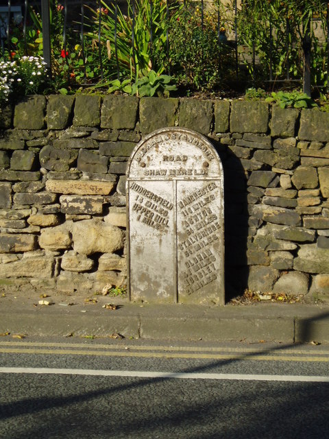
English: Flat turnpike milestone This milestone, on the Oldham to Stanage Turnpike, is unusual in that it is only two-dimensional, presumably because the carriageway is too close to allow it to stick out. |
| Date | |
| Source | From geograph.org.uk |
| Author | David Watson |
| Attribution (required by the license) | David Watson / Flat turnpike milestone / |
| Camera location | | View this and other nearby images on: OpenStreetMap |
|---|
Licensing edit

|
This image was taken from the Geograph project collection. See this photograph's page on the Geograph website for the photographer's contact details. The copyright on this image is owned by David Watson and is licensed for reuse under the Creative Commons Attribution-ShareAlike 2.0 license.
|
This file is licensed under the Creative Commons Attribution-Share Alike 2.0 Generic license.
Attribution: David Watson
- You are free:
- to share – to copy, distribute and transmit the work
- to remix – to adapt the work
- Under the following conditions:
- attribution – You must give appropriate credit, provide a link to the license, and indicate if changes were made. You may do so in any reasonable manner, but not in any way that suggests the licensor endorses you or your use.
- share alike – If you remix, transform, or build upon the material, you must distribute your contributions under the same or compatible license as the original.
File history
Click on a date/time to view the file as it appeared at that time.
| Date/Time | Thumbnail | Dimensions | User | Comment | |
|---|---|---|---|---|---|
| current | 18:49, 1 January 2009 | | 480 × 640 (119 KB) | Parrot of Doom (talk | contribs) | {{Information |Description={{en|1=This milestone, on the Oldham to Stanage Turnpike, is unusual in that it is only two-dimensional, presumably because the carriageway is too close to allow it to stick out.}} |Source=http://www.geograph.org.uk/photo/948423 |
You cannot overwrite this file.
File usage on Commons
There are no pages that use this file.