File:Greenland smoke ESA382360.jpg

Original file (2,502 × 1,408 pixels, file size: 473 KB, MIME type: image/jpeg)
Captions
Captions
Summary edit
| Description |
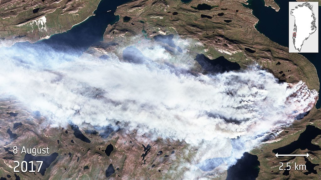
English: Greenland is usually associated with ice and snow, but the country has fallen victim to a large wildfire that has been raging since the end of July. The smoke billowing from the fire was imaged by the Copernicus Sentinel-2A satellite on 8 August 2017.
Greenland is almost entirely covered by a thick ice sheet, but there are exposed carbon-rich peatlands along the coast. The fire, which is in the western part of the country, appears to be a peatland fire. The fear is that the fire may have broken out because permafrost is melting, making the peat more susceptible to catching fire. Also, since it is peat, which can be used as a fuel, it could burn for some time. The Sentinel-2 mission is based on a constellation of two identical satellites: Sentinel-2A and Sentinel-2B, each carrying a high-resolution multispectral camera working in 13 wavelength bands. The combination of high-resolution, novel spectral capabilities, a field of vision covering 290 km and frequent revisit times is providing unprecedented views of Earth. Information from this mission is helping to improve agricultural practices, monitor the world’s forests, detect pollution in lakes and coastal waters, and contribute to disaster mapping. An animation of the fire that uses different combinations of these bands is alsoavailable. It shows the fire in natural colour (as here), highlights the flames and shows the burnt areas. |
| Date | |
| Source | http://www.esa.int/spaceinimages/Images/2017/08/Greenland_smoke |
| Author | European Space Agency |
| Permission (Reusing this file) |
contains modified Copernicus Sentinel data (2017), processed by ESA,CC BY-SA 3.0 IGO |
| Title | Greenland smoke |
| System | Copernicus |
| Mission | Sentinel-2 |
| Activity | Observing the Earth |
Licensing edit
- You are free:
- to share – to copy, distribute and transmit the work
- to remix – to adapt the work
- Under the following conditions:
- attribution – You must give appropriate credit, provide a link to the license, and indicate if changes were made. You may do so in any reasonable manner, but not in any way that suggests the licensor endorses you or your use.
- share alike – If you remix, transform, or build upon the material, you must distribute your contributions under the same or compatible license as the original.

|
This image contains data from a satellite in the Copernicus Programme, such as Sentinel-1, Sentinel-2 or Sentinel-3. Attribution is required when using this image.
Attribution: Contains modified Copernicus Sentinel data {{{year}}}
The use of Copernicus Sentinel Data is regulated under EU law (Commission Delegated Regulation (EU) No 1159/2013 and Regulation (EU) No 377/2014). Relevant excerpts:
Free access shall be given to GMES dedicated data [...] made available through GMES dissemination platforms [...].
Access to GMES dedicated data [...] shall be given for the purpose of the following use in so far as it is lawful:
GMES dedicated data [...] may be used worldwide without limitations in time.
GMES dedicated data and GMES service information are provided to users without any express or implied warranty, including as regards quality and suitability for any purpose. |
File history
Click on a date/time to view the file as it appeared at that time.
| Date/Time | Thumbnail | Dimensions | User | Comment | |
|---|---|---|---|---|---|
| current | 15:55, 10 August 2017 | | 2,502 × 1,408 (473 KB) | Fæ (talk | contribs) | European Space Agency, Id 382360, http://www.esa.int/spaceinimages/Images/2017/08/Greenland_smoke, User:Fæ/Project_list/ESA |
You cannot overwrite this file.
File usage on Commons
The following page uses this file: