File:Gualeguaychú as seen by SAOCOM 1A.jpg

Size of this preview: 800 × 399 pixels. Other resolutions: 320 × 160 pixels | 640 × 319 pixels | 1,493 × 745 pixels.
Original file (1,493 × 745 pixels, file size: 708 KB, MIME type: image/jpeg)
Captions
Captions
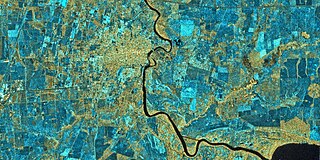
The city of Gualeguaychú and it's surroundings as seen by the SAOCOM 1A satellite.
Summary edit
| Description |
Español: La ciudad de Gualeguaychú y sus alrededores visto por el satélite SAOCOM 1A.
English: The city of Gualeguaychú and it's surroundings as seen by the SAOCOM 1A satellite. |
| Date | |
| Source | https://www.argentina.gob.ar/noticias/nuevos-proyectos-de-investigacion-utilizaran-informacion-de-los-satelites-saocom |
| Author | CONAE |
Licensing edit
This file is licensed under the Creative Commons Attribution 4.0 International license.
- You are free:
- to share – to copy, distribute and transmit the work
- to remix – to adapt the work
- Under the following conditions:
- attribution – You must give appropriate credit, provide a link to the license, and indicate if changes were made. You may do so in any reasonable manner, but not in any way that suggests the licensor endorses you or your use.
File history
Click on a date/time to view the file as it appeared at that time.
| Date/Time | Thumbnail | Dimensions | User | Comment | |
|---|---|---|---|---|---|
| current | 19:43, 3 November 2021 | | 1,493 × 745 (708 KB) | BugWarp (talk | contribs) | Uploaded a work by CONAE from https://www.argentina.gob.ar/noticias/nuevos-proyectos-de-investigacion-utilizaran-informacion-de-los-satelites-saocom with UploadWizard |
You cannot overwrite this file.
File usage on Commons
There are no pages that use this file.