File:Gulfport-apt-19feb1992.jpg

Size of this preview: 659 × 600 pixels. Other resolutions: 264 × 240 pixels | 527 × 480 pixels | 913 × 831 pixels.
Original file (913 × 831 pixels, file size: 277 KB, MIME type: image/jpeg)
Captions
Captions
Add a one-line explanation of what this file represents
Summary edit
| Description |
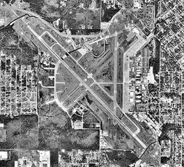
English: Aerial image of Gulfport-Biloxi International Airport, Mississippi |
| Date | |
| Source | USGS The National Map, via MSR Maps (formerly TerraServer-USA) |
| Author | United States Geological Survey (USGS) |
| Permission (Reusing this file) |
Public domain |
Licensing edit
This image is in the public domain in the United States because it only contains materials that originally came from the United States Geological Survey, an agency of the United States Department of the Interior. For more information, see the official USGS copyright policy.
|
File history
Click on a date/time to view the file as it appeared at that time.
| Date/Time | Thumbnail | Dimensions | User | Comment | |
|---|---|---|---|---|---|
| current | 18:50, 21 April 2009 | | 913 × 831 (277 KB) | Bwmoll3 (talk | contribs) | {{Information |Description={{en|1=Gulfport-Biloxi International Airport Mississippi}} |Source=US Geological Survery via http://terraserver-usa.com/map.aspx?t=1&s=12&lon=-89.07&lat=30.407222&w=1000&h=1000&opt=0&f=&fs=8&fc=ffffff99&lp=---+None+--- |Autho |
You cannot overwrite this file.
File usage on Commons
The following page uses this file:
File usage on other wikis
The following other wikis use this file:
- Usage on ceb.wikipedia.org
- Usage on de.wikipedia.org
- Usage on de.wikivoyage.org
- Usage on en.wikipedia.org
- Usage on en.wikivoyage.org
- Usage on fa.wikipedia.org
- Usage on fr.wikipedia.org
- Usage on hu.wikipedia.org
- Usage on it.wikipedia.org
- Usage on pl.wikipedia.org
- Usage on ro.wikipedia.org
- Usage on tg.wikipedia.org
- Usage on ur.wikipedia.org
- Usage on vi.wikipedia.org
- Usage on www.wikidata.org