File:Gunbarrel Highway Map.png

Size of this preview: 799 × 125 pixels. Other resolutions: 320 × 50 pixels | 640 × 100 pixels | 1,024 × 160 pixels | 1,280 × 200 pixels | 6,641 × 1,040 pixels.
Original file (6,641 × 1,040 pixels, file size: 523 KB, MIME type: image/png)
Captions
Captions
Add a one-line explanation of what this file represents
Summary edit
| Description |
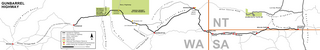
English: Map of the Gunbarrel Highway, Australia, showing the track itself, most major and some minor sideroads, towns and other settlements along the way as well as nature parks and some sights. Based on several online sources, mostly Wilmap Australia and ExplorOz.
Important: This is the Inkscape-rendered PNG of its corresponding SVG file, File:Gunbarrel Highway Map.svg. The PNGs automatically created by the MediaWiki software on uploading the SVG can NOT be used. I had to uploaded the PNG seperately because Wikimedia's SVG renderer has troubles with Inkscape's bended text fields, with the outcome that they are not visible in the rendered files. For use in articles, please embed THIS file (i.e. "~.png"). The SVG is only for editing purposes, NOT for use in articles.
Deutsch: Karte des Gunbarrel Highways in Australien, mit dem Track selbst, den meisten größeren und einigen kleineren Nebenstraßen, Towns und andere Siedlungen entlang des Wegs sowie Naturparks und ein paar Sehenswürdigkeiten. Basierend auf verschiedenen Online-Quellen, vor allem Wilmap Australia und ExplorOz. Wichtig: Dies ist das von Inkscape gerenderte PNG seiner entsprechenden SVG-Datei, File:Gunbarrel Highway Map.svg. Die PNGs, die beim Hochladen des SVGs von der MediaWiki-Software automatisch erstellt wurden, können NICHT verwendet werden. Ich musste dieses PNG separat hochladen, da der Wikimedia-SVG-Renderer Probleme mit Inkscapes gekrümmten Textfeldern hat, was dazu führt, dass diese in den gerenderten Dateien nicht sichtbar sind. Binde für den Gebrauch in Artikeln bitte DIESE Datei (also "~.png") ein. Das SVG ist nur für Bearbeitungszwecke gedacht, NICHT für den Gebrauch in Artikeln. |
| Date | |
| Source | Own work |
| Author | Christallkeks |
| Other versions | File:Gunbarrel Highway Map.svg |
Licensing edit
I, the copyright holder of this work, hereby publish it under the following license:
This file is licensed under the Creative Commons Attribution-Share Alike 3.0 Unported license.
- You are free:
- to share – to copy, distribute and transmit the work
- to remix – to adapt the work
- Under the following conditions:
- attribution – You must give appropriate credit, provide a link to the license, and indicate if changes were made. You may do so in any reasonable manner, but not in any way that suggests the licensor endorses you or your use.
- share alike – If you remix, transform, or build upon the material, you must distribute your contributions under the same or compatible license as the original.
File history
Click on a date/time to view the file as it appeared at that time.
| Date/Time | Thumbnail | Dimensions | User | Comment | |
|---|---|---|---|---|---|
| current | 13:10, 9 September 2013 | 6,641 × 1,040 (523 KB) | Christallkeks (talk | contribs) | Added Old Gunbarrel Highway | |
| 07:13, 24 October 2012 | 6,641 × 923 (589 KB) | Christallkeks (talk | contribs) | {{Information |Description ={{en|1=Map of the Gunbarrel Highway, Australia, showing the track itself, most major and some minor sideroads, towns and other settlements along the way as well as nature parks and some sights. Based on several online sou... |
You cannot overwrite this file.
File usage on Commons
The following page uses this file:
File usage on other wikis
The following other wikis use this file:
- Usage on de.wikipedia.org
- Usage on en.wikivoyage.org
- Usage on fr.wikipedia.org
- Usage on nl.wikipedia.org
- Usage on sv.wikipedia.org
- Usage on www.wikidata.org