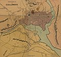
File:H. H. Lloyd & Co's Campaign Military Charts showing the Principal Strategic Places of Interest 1861 UTA (District of Columbia).jpg

Original file (1,098 × 1,035 pixels, file size: 206 KB, MIME type: image/jpeg)
Captions
Captions
Summary edit
| Title |
English: District of Columbia from H. H. Lloyd & Co.'s Military Charts Showing the Principal Strategic Places of Interest |
||||||||||||||||||||||||||
| DescriptionH. H. Lloyd & Co's Campaign Military Charts showing the Principal Strategic Places of Interest 1861 UTA (District of Columbia).jpg |
English: Numerous points of strategic interest appear on one large sheet published by H. H. Lloyd & Co. of New York in the first year of the American Civil War. Of the seventeen charts and maps included, only the central map, three Mississippi River sections at upper left, and Galveston Bay chart at lower left relate to the trans-Mississippi West – an indication of the nation's primary areas of focus during this period. The charts were compiled by Egbert Viele, who had an interesting military and civilian career both before, during, and after the war, serving variously as an Army lieutenant from 1847-1853, then as a civil and military engineer, State Engineer of New Jersey from 1855, brigadier general of U.S. Volunteers from 1861-1863, then civil engineer again, chief engineer with a railroad, commissioner of parks for New York City, and U.S. Representative from New York from 1885-1887. It is important to note that another firm actively publishing Civil War-related maps at this time was James T. Lloyd, also of New York, who complained that H. H. Lloyd's maps were easily confused with, but of inferior quality to, his own. |
||||||||||||||||||||||||||
| Date | |||||||||||||||||||||||||||
| Source | UTA Libraries Cartographic Connections: map / text | ||||||||||||||||||||||||||
| Creator |
creator QS:P170,Q5347713 Charles Haskins |
||||||||||||||||||||||||||
| Credit line |
English: UTA Libraries Special Collections |
||||||||||||||||||||||||||
| Geotemporal data | |||||||||||||||||||||||||||
| Map location | United States of America | ||||||||||||||||||||||||||
| Georeferencing | Georeference the map in Wikimaps Warper If inappropriate please set warp_status = skip to hide. | ||||||||||||||||||||||||||
| Bibliographic data | |||||||||||||||||||||||||||
| Place of publication | New York City | ||||||||||||||||||||||||||
| Printed by |
J. D. Terry |
||||||||||||||||||||||||||
| Archival data | |||||||||||||||||||||||||||
| Collection |
institution QS:P195,Q1230739 |
||||||||||||||||||||||||||
| Dimensions |
height: 96 cm (37.7 in); width: 73 cm (28.7 in) dimensions QS:P2048,96U174728 dimensions QS:P2049,73U174728 |
||||||||||||||||||||||||||
| Medium |
chromolithograph medium QS:P186,Q1121337 |
||||||||||||||||||||||||||
| artwork-references |
Stephenson, Richard W. (1989) Civil War Maps: An Annotated List of Maps and Atlases in the Library of Congress (2nd ed.), Washington, D.C.: Library of Congress, no. 18 , pp. 9−11, 40 "Viele, Egbert L." in Biographical Directory of the United States Congress Retrieved on April 24, 2008. |
||||||||||||||||||||||||||
| Other versions |
|
||||||||||||||||||||||||||
Licensing edit

|
This file was provided to Wikimedia Commons by the University of Texas at Arlington Libraries as part of a cooperation project. The University of Texas at Arlington Libraries is part of the University of Texas at Arlington, a public research university located in Arlington, Texas.
|
| Public domainPublic domainfalsefalse |
|
The author died in 1902, so this work is in the public domain in its country of origin and other countries and areas where the copyright term is the author's life plus 100 years or fewer. This work is in the public domain in the United States because it was published (or registered with the U.S. Copyright Office) before January 1, 1929. | |
| This file has been identified as being free of known restrictions under copyright law, including all related and neighboring rights. | |
https://creativecommons.org/publicdomain/mark/1.0/PDMCreative Commons Public Domain Mark 1.0falsefalse
File history
Click on a date/time to view the file as it appeared at that time.
| Date/Time | Thumbnail | Dimensions | User | Comment | |
|---|---|---|---|---|---|
| current | 17:02, 18 March 2022 |  | 1,098 × 1,035 (206 KB) | Michael Barera (talk | contribs) | File:H. H. Lloyd & Co's Campaign Military Charts showing the Principal Strategic Places of Interest 1861 UTA.jpg cropped 59 % horizontally, 71 % vertically using CropTool with precise mode. |
You cannot overwrite this file.


