File:HSRC Neretva Vallis (zoom 12).png

Size of this preview: 800 × 320 pixels. Other resolutions: 320 × 128 pixels | 640 × 256 pixels | 1,024 × 410 pixels | 1,280 × 512 pixels | 4,000 × 1,600 pixels.
Original file (4,000 × 1,600 pixels, file size: 4.69 MB, MIME type: image/png)
Captions
Captions
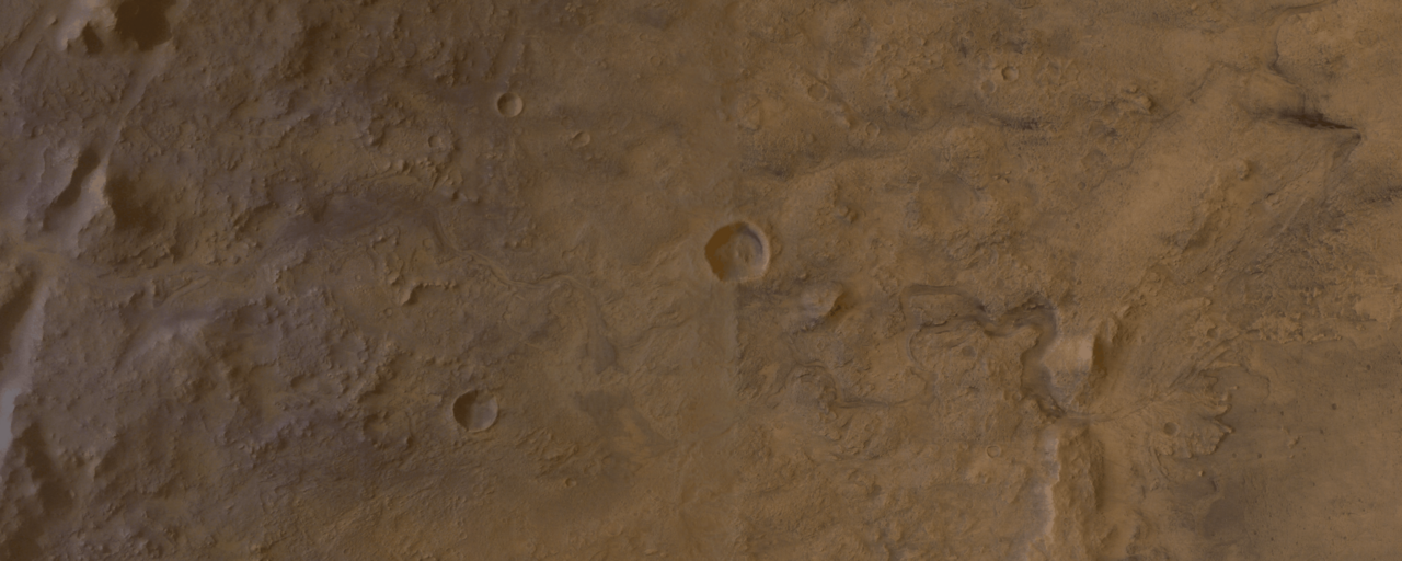
Neretva Vallis in MC-13 Mars quadrangle (zoom 12) 18.7°N 76÷77°E
Summary edit
.png&action=edit§ion=1)
| Description |
English: The HSRC orbital image of the Neretva Vallis in MC-13 Syrtis Major Mars quadrangle (18.7°N 76÷77°E, zoom 12).
One of the Nili Fossae grabens is partially seen to the west (left) while the rim of Jezero crater with the delta of Neretva are seen at east (right). In the center of the image a 5 km-wide Angelica crater is seen on the left (northern) bank of what was Neretva river 3.8 billion years ago. |
| Date | between 2003 and 2008 |
| Source | https://maps.planet.fu-berlin.de/#map=12/4531297.11/1096520.56 |
| Author | HSRC/FUB/DLR/ESA |
Licensing edit
.png&action=edit§ion=2)
This file is licensed under the Creative Commons Attribution 3.0 IGO license.
- You are free:
- to share – to copy, distribute and transmit the work
- to remix – to adapt the work
- Under the following conditions:
- attribution – You must give appropriate credit, provide a link to the license, and indicate if changes were made. You may do so in any reasonable manner, but not in any way that suggests the licensor endorses you or your use.
File history
Click on a date/time to view the file as it appeared at that time.
| Date/Time | Thumbnail | Dimensions | User | Comment | |
|---|---|---|---|---|---|
| current | 07:14, 20 October 2021 | 4,000 × 1,600 (4.69 MB) | Cherurbino (talk | contribs) | Uploaded a work by HSRC/FUB/DLR/ESA from https://maps.planet.fu-berlin.de/#map=12/4531297.11/1096520.56 with UploadWizard |
You cannot overwrite this file.
File usage on Commons
The following page uses this file:
File usage on other wikis
The following other wikis use this file:
- Usage on it.wikipedia.org
- Usage on ru.wikipedia.org
- Usage on www.wikidata.org
.png&oldid=720211075)