File:HUNTINGTON Solano-Reeve 1874-11-20 Map of Rincon Denis Bear.jpg

Original file (7,645 × 8,551 pixels, file size: 11.96 MB, MIME type: image/jpeg)
Captions
Captions
Summary edit
| Description |
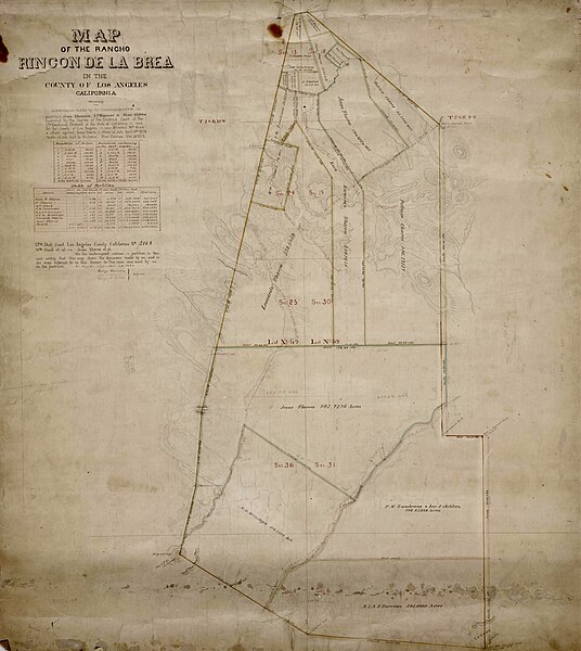
English: HUNTINGTON Solano-Reeve 1874-11-20 Map of Rincon Denis Bear |
| Date | |
| Source |
Title Map of the Rancho Rincón de la Brea subdivision. Creator Hansen, George, 1824-1897, creator. Date Searchable 1874-11-20 Date 1874 November 20 Call Number SR_Map_0793 Physical Description 1 ms. map ; 37 x 20 in., on sheet 38 3/8 x 34 1/8 in., ink on paper Scale 1 : 10 chains Location depicted Rincon de la Brea, Rancho Rowland Heights Brea Description Showing parcel owners, color highlighting, extensive hachures, acreages. Tables: boundaries, partition data. Case No. 2168 Wm. Slack et al v. Jesus Ybarra et al, signed by witnesses: Subdivision made by the Commissioners in partition (incl. Hansen). Subjects Brea (Calif.) California -- History -- 1850-1950. Historical maps. (aat) Los Angeles County (Calif.) -- Maps. Ranches -- California, Southern -- Maps. Real property -- Maps. Rowland Heights (Calif.) Surveying -- California, Southern -- History. Physical Collection Solano-Reeve collection Rights For information on use of Digital Library materials, please see Library Rights and Permissions: https://www.huntington.org/library-rights-permissions Digital Collection Maps, Huntington Digital Library Digitization Specifications High Res Unique Digital Identifier 313776 IIIF Manifest https://hdl.huntington.org/iiif/info/p15150coll4/12289/manifest.json IIIF Image https://hdl.huntington.org/digital/iiif/p15150coll4/12289/full/full/0/default.jpg |
| Author | U.S. Surveyors |
Licensing edit
This work is in the public domain in the United States because it was published (or registered with the U.S. Copyright Office) before January 1, 1929.
Public domain works must be out of copyright in both the United States and in the source country of the work in order to be hosted on the Commons. If the work is not a U.S. work, the file must have an additional copyright tag indicating the copyright status in the source country.
Note: This tag should not be used for sound recordings. |
File history
Click on a date/time to view the file as it appeared at that time.
| Date/Time | Thumbnail | Dimensions | User | Comment | |
|---|---|---|---|---|---|
| current | 05:59, 1 April 2023 | | 7,645 × 8,551 (11.96 MB) | Jengod (talk | contribs) | Uploaded a work by U.S. Surveyors from Title Map of the Rancho Rincón de la Brea subdivision. Creator Hansen, George, 1824-1897, creator. Date Searchable 1874-11-20 Date 1874 November 20 Call Number SR_Map_0793 Physical Description 1 ms. map ; 37 x 20 in., on sheet 38 3/8 x 34 1/8 in., ink on paper Scale 1 : 10 chains Location depicted Rincon de la Brea, Rancho Rowland Heights Brea Description Showing parcel owners, color highlighting, extensive hachures, acreages. Tables: boundaries, partiti... |
You cannot overwrite this file.
File usage on Commons
There are no pages that use this file.
File usage on other wikis
The following other wikis use this file:
- Usage on en.wikipedia.org