File:HaigerlochZentrum2018-05-09-12-18-40.jpg

Size of this preview: 800 × 516 pixels. Other resolutions: 320 × 207 pixels | 640 × 413 pixels | 1,024 × 661 pixels | 1,280 × 826 pixels | 2,560 × 1,652 pixels | 4,375 × 2,824 pixels.
Original file (4,375 × 2,824 pixels, file size: 9.87 MB, MIME type: image/jpeg)
Captions
Captions
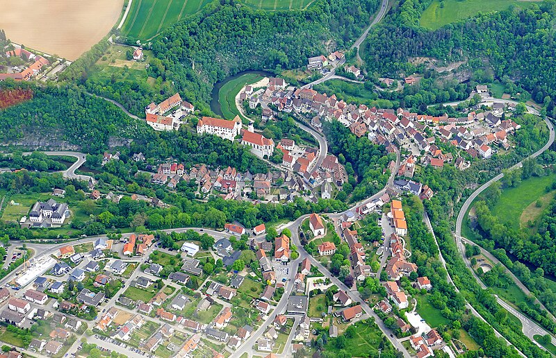
Aerial view of the centre of Haigerloch
Summary
edit
| Description |
Deutsch: Luftbild des Zentrums von Haigerloch, aufgenommen aus einem Tragschrauber aus einer Höhe von etwa 4100 Fuß. Deutlich zu erkennen ist das Muschelkalktal der Eyach, das in Haigerloch zwei Schlingen bildet, ebenso Schlosskirche und Schloss Haigerloch.
English: Aerial view of the centre of Haigerloch, taken from a gyrocopter at an altitude of about 4100 feet. The shell limestone valley of the Eyach, which forms two loops in Haigerloch, is clearly visible, as are the castle church and Haigerloch castle. |
| Date | |
| Source | Own work |
| Author | Rolf Kickuth |
Licensing
edit
I, the copyright holder of this work, hereby publish it under the following license:
This file is licensed under the Creative Commons Attribution-Share Alike 4.0 International license.
- You are free:
- to share – to copy, distribute and transmit the work
- to remix – to adapt the work
- Under the following conditions:
- attribution – You must give appropriate credit, provide a link to the license, and indicate if changes were made. You may do so in any reasonable manner, but not in any way that suggests the licensor endorses you or your use.
- share alike – If you remix, transform, or build upon the material, you must distribute your contributions under the same or compatible license as the original.
File history
Click on a date/time to view the file as it appeared at that time.
| Date/Time | Thumbnail | Dimensions | User | Comment | |
|---|---|---|---|---|---|
| current | 20:28, 14 January 2021 | | 4,375 × 2,824 (9.87 MB) | Laniakea-rubikon (talk | contribs) | Uploaded own work with UploadWizard |
You cannot overwrite this file.
File usage on Commons
The following 2 pages use this file:
File usage on other wikis
The following other wikis use this file:
- Usage on de.wikipedia.org