File:Hakata Exit Station Square S from Hakata Bus Terminal 20230725.jpg

Size of this preview: 800 × 600 pixels. Other resolutions: 320 × 240 pixels | 640 × 480 pixels | 1,024 × 768 pixels | 1,280 × 960 pixels | 2,560 × 1,920 pixels | 4,000 × 3,000 pixels.
Original file (4,000 × 3,000 pixels, file size: 3.75 MB, MIME type: image/jpeg)
Captions
Captions
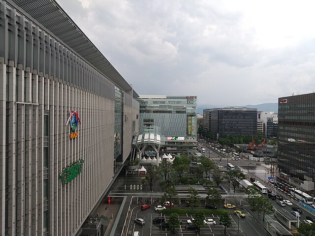
Hakata Exit Station Square, the view S from Hakata Bus Terminal (Fukuoka City, Japan)
Summary edit
| Description |
日本語: 博多口駅前広場、博多バスターミナルより南の眺望(所在地:812-0012福岡市博多区博多駅中央街)
English: Hakata Exit Station Square, the view south from Hakata Bus Terminal (Address: Hakata-eki-chūōgai, Hakata-ku, Fukuoka City, Japan 812-0012) |
| Date | |
| Source | Own work |
| Author | Hirho |
| Camera location | | View this and other nearby images on: OpenStreetMap |
|---|
博多口駅前広場(写真の中央)は、2011年に実施された再整備により、交通広場が一か所(写真の中央前方)に集約され、また、周辺地区にも繋がるように地下(地下通路、地下街)や地上二階に整備された歩行者動線(建築物内部の歩行者デッキ、道路を跨ぐ歩行者連絡橋)と相俟って広く一体的な歩行者空間が構成されている。
- 博多口駅前広場の位置:
| Object location | | View this and other nearby images on: OpenStreetMap |
|---|
- 博多駅歩行者連絡橋(中央部分)の位置:
| Object location | | View this and other nearby images on: OpenStreetMap |
|---|
駅前広場の周囲(写真に見える範囲)には、博多駅地下街(駅前広場の真下)、JR博多シティ、KITTE博多、福岡センタービルなどがあり、ほかの地域(写真の外の範囲)には、博多バスターミナル、JRJP博多ビル、博多深見パークビルディング、HEARTSバスステーション博多、福岡朝日ビルなどがあり、お互いに連結されている。
- 博多駅地下街の位置:
| Object location | | View this and other nearby images on: OpenStreetMap |
|---|
- JR博多シティの位置:
| Object location | | View this and other nearby images on: OpenStreetMap |
|---|
- KITTE博多の位置:
| Object location | | View this and other nearby images on: OpenStreetMap |
|---|
- 福岡センタービルの位置:
| Object location | | View this and other nearby images on: OpenStreetMap |
|---|
- 博多バスターミナルの位置:
| Object location | | View this and other nearby images on: OpenStreetMap |
|---|
- JRJP博多ビルの位置:
| Object location | | View this and other nearby images on: OpenStreetMap |
|---|
- 博多深見パークビルディングの位置:
| Object location | | View this and other nearby images on: OpenStreetMap |
|---|
- HEARTSバスステーション博多の位置:
| Object location | | View this and other nearby images on: OpenStreetMap |
|---|
- 福岡朝日ビルの位置:
| Object location | | View this and other nearby images on: OpenStreetMap |
|---|
Licensing edit
I, the copyright holder of this work, hereby publish it under the following license:
This file is licensed under the Creative Commons Attribution-Share Alike 4.0 International license.
- You are free:
- to share – to copy, distribute and transmit the work
- to remix – to adapt the work
- Under the following conditions:
- attribution – You must give appropriate credit, provide a link to the license, and indicate if changes were made. You may do so in any reasonable manner, but not in any way that suggests the licensor endorses you or your use.
- share alike – If you remix, transform, or build upon the material, you must distribute your contributions under the same or compatible license as the original.
File history
Click on a date/time to view the file as it appeared at that time.
| Date/Time | Thumbnail | Dimensions | User | Comment | |
|---|---|---|---|---|---|
| current | 14:34, 29 March 2024 | | 4,000 × 3,000 (3.75 MB) | Hirho (talk | contribs) | Uploaded own work with UploadWizard |
You cannot overwrite this file.
File usage on Commons
The following page uses this file: