File:Hamish 2009-03-09 2350Z.jpg

Size of this preview: 461 × 599 pixels. Other resolutions: 184 × 240 pixels | 369 × 480 pixels | 591 × 768 pixels | 788 × 1,024 pixels | 1,575 × 2,048 pixels | 6,000 × 7,800 pixels.
Original file (6,000 × 7,800 pixels, file size: 6.78 MB, MIME type: image/jpeg)
Captions
Captions
Add a one-line explanation of what this file represents
Summary edit
| Description |
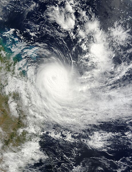
English: Tropical Cyclone Hamish crept a little farther southeast along the coast of Queensland, Australia, in the time that elapsed between an image of the area captured by NASA’s Aqua satellite on March 9 at 1:30 p.m. local time in Queensland and this image of the storm captured by the Terra satellite the next morning at 9:50 a.m. (March 9, 23:50 UTC). The eye of the storm was northeast of Fraser Island, which is about 300 kilometers north of Queensland’s capital and largest city, Brisbane. At the time the image was taken, Hamish was in the process of weakening from a Category 3 to a Category 2 storm |
| Date | |
| Source | http://earthobservatory.nasa.gov/NaturalHazards/view.php?id=37429 |
| Author | NASA image by Jeff Schmaltz, MODIS Rapid Response Team, Goddard Space Flight Center. |
Licensing edit
| This file is in the public domain in the United States because it was solely created by NASA. NASA copyright policy states that "NASA material is not protected by copyright unless noted". (See Template:PD-USGov, NASA copyright policy page or JPL Image Use Policy.) | ||
 |
Warnings:
|
File history
Click on a date/time to view the file as it appeared at that time.
| Date/Time | Thumbnail | Dimensions | User | Comment | |
|---|---|---|---|---|---|
| current | 01:11, 7 August 2023 | | 6,000 × 7,800 (6.78 MB) | Nino Marakot (talk | contribs) | Original color |
| 13:11, 16 August 2010 |  | 6,000 × 7,800 (6.23 MB) | Supportstorm (talk | contribs) | {{Information |Description={{en|1=Tropical Cyclone Hamish crept a little farther southeast along the coast of Queensland, Australia, in the time that elapsed between an image of the area captured by NASA’s Aqua satellite on March 9 at 1:30 p.m. local ti |
You cannot overwrite this file.
File usage on Commons
There are no pages that use this file.