File:Haudegen.png

Original file (2,294 × 1,865 pixels, file size: 1.34 MB, MIME type: image/png)
Captions
Captions
Summary edit
| Description |
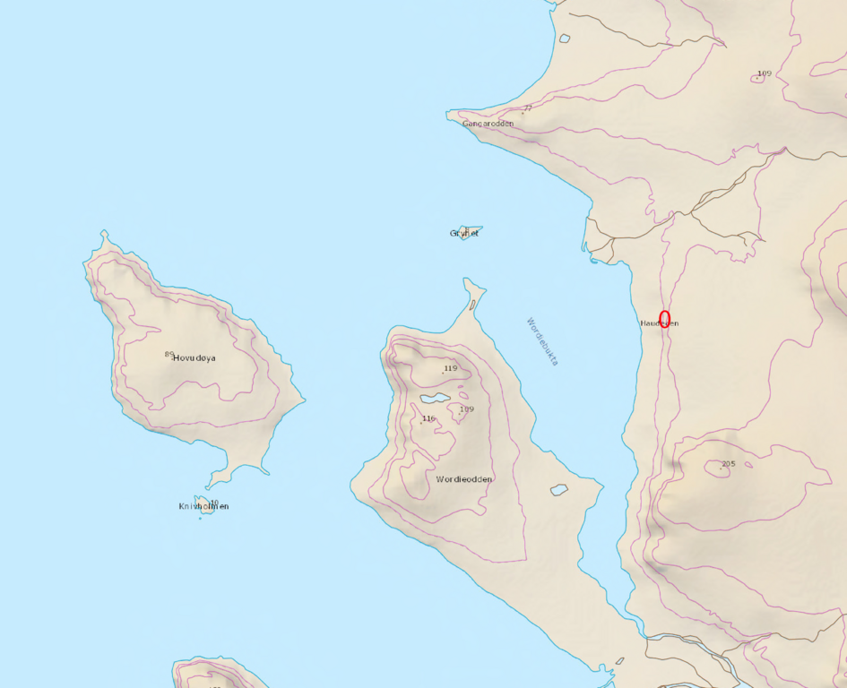
Deutsch: Genaue Position von der Wetterstation Haudegen und des Gedenksteins
English: Exact Position of the Weather Station "Haudegen" and the Memorial Monument |
| Date | |
| Source | Nordk Polarinstitut |
| Author |
Kartdata © Norsk Polarinstitutt, versjon: April 2016 Kartdataene er lisensiert under Creative Commons Navngivelse 4.0 Internasjonal-lisensen. For å se en kopi av denne lisensen, besøk https://creativecommons.org/licenses/by/4.0/ eller send et brev til Creative Commons, PO Box 1866, Mountain View, CA 94042, USA. KARTDATA FRA NORSK POLARINSTITUTT SKAL KREDITERES VED BRUK. DELER AV KARTDATAENE ER AV ELDRE DATO OG IKKE EGNET FOR NAVIGASJON. Se også lisenstekstens kapittel 5. Garantier og ansvarsfraskrivelse. For metadata, produktspesifikasjoner og kartdatanedlastning, besøk http://data.npolar.no. Denne tekstfilen skal følge umodifisert med alle kopier av kartdataene, deler av kartdataene eller avledede data. - - - - - Map data © Norwegian Polar Institute, version: April 2016 The map data is licensed under the Creative Commons Attribution 4.0 International License. To view a copy of this license, visit https://creativecommons.org/licenses/by/4.0/ or send a letter to Creative Commons, PO Box 1866, Mountain View, CA 94042, USA. MAP DATA FROM THE NORWEGIAN POLAR INSTITUTE MUST BE CREDITED WHEN USED. PARTS OF THE MAP DATA ARE OF OLDER ORIGIN AND NOT SUITED FOR NAVIGATION. See also licence Section 5 – Disclaimer of Warranties and Limitation of Liability. For metadata, product specifications and map data downloads, visit http://data.npolar.no. This text file must follow unmodified with all copies of the map data, parts of the map data, or derived data. Kartdata © Norsk Polarinstitutt, versjon: April 2016 Kartdataene er lisensiert under Creative Commons Navngivelse 4.0 Internasjonal-lisensen. For å se en kopi av denne lisensen, besøk https://creativecommons.org/licenses/by/4.0/ eller send et brev til Creative Commons, PO Box 1866, Mountain View, CA 94042, USA. KARTDATA FRA NORSK POLARINSTITUTT SKAL KREDITERES VED BRUK. DELER AV KARTDATAENE ER AV ELDRE DATO OG IKKE EGNET FOR NAVIGASJON. Se også lisenstekstens kapittel 5. Garantier og ansvarsfraskrivelse. For metadata, produktspesifikasjoner og kartdatanedlastning, besøk http://data.npolar.no. Denne tekstfilen skal følge umodifisert med alle kopier av kartdataene, deler av kartdataene eller avledede data. - - - - - Map data © Norwegian Polar Institute, version: April 2016 The map data is licensed under the Creative Commons Attribution 4.0 International License. To view a copy of this license, visit https://creativecommons.org/licenses/by/4.0/ or send a letter to Creative Commons, PO Box 1866, Mountain View, CA 94042, USA. MAP DATA FROM THE NORWEGIAN POLAR INSTITUTE MUST BE CREDITED WHEN USED. PARTS OF THE MAP DATA ARE OF OLDER ORIGIN AND NOT SUITED FOR NAVIGATION. See also licence Section 5 – Disclaimer of Warranties and Limitation of Liability. For metadata, product specifications and map data downloads, visit http://data.npolar.no. This text file must follow unmodified with all copies of the map data, parts of the map data, or derived data. Kartdata © Norsk Polarinstitutt, versjon: April 2016 Kartdataene er lisensiert under Creative Commons Navngivelse 4.0 Internasjonal-lisensen. For å se en kopi av denne lisensen, besøk https://creativecommons.org/licenses/by/4.0/ eller send et brev til Creative Commons, PO Box 1866, Mountain View, CA 94042, USA. KARTDATA FRA NORSK POLARINSTITUTT SKAL KREDITERES VED BRUK. DELER AV KARTDATAENE ER AV ELDRE DATO OG IKKE EGNET FOR NAVIGASJON. Se også lisenstekstens kapittel 5. Garantier og ansvarsfraskrivelse. For metadata, produktspesifikasjoner og kartdatanedlastning, besøk http://data.npolar.no. Denne tekstfilen skal følge umodifisert med alle kopier av kartdataene, deler av kartdataene eller avledede data. - - - - - Map data © Norwegian Polar Institute, version: April 2016 The map data is licensed under the Creative Commons Attribution 4.0 International License. To view a copy of this license, visit https://creativecommons.org/licenses/by/4.0/ or send a letter to Creative Commons, PO Box 1866, Mountain View, CA 94042, USA. MAP DATA FROM THE NORWEGIAN POLAR INSTITUTE MUST BE CREDITED WHEN USED. PARTS OF THE MAP DATA ARE OF OLDER ORIGIN AND NOT SUITED FOR NAVIGATION. See also licence Section 5 – Disclaimer of Warranties and Limitation of Liability. For metadata, product specifications and map data downloads, visit http://data.npolar.no. This text file must follow unmodified with all copies of the map data, parts of the map data, or derived data. Kartdata © Norsk Polarinstitutt, versjon: April 2016 Kartdataene er lisensiert under Creative Commons Navngivelse 4.0 Internasjonal-lisensen. For å se en kopi av denne lisensen, besøk https://creativecommons.org/licenses/by/4.0/ eller send et brev til Creative Commons, PO Box 1866, Mountain View, CA 94042, USA. KARTDATA FRA NORSK POLARINSTITUTT SKAL KREDITERES VED BRUK. DELER AV KARTDATAENE ER AV ELDRE DATO OG IKKE EGNET FOR NAVIGASJON. Se også lisenstekstens kapittel 5. Garantier og ansvarsfraskrivelse. For metadata, produktspesifikasjoner og kartdatanedlastning, besøk http://data.npolar.no. Denne tekstfilen skal følge umodifisert med alle kopier av kartdataene, deler av kartdataene eller avledede data. - - - - - Map data © Norwegian Polar Institute, version: April 2016 The map data is licensed under the Creative Commons Attribution 4.0 International License. To view a copy of this license, visit https://creativecommons.org/licenses/by/4.0/ or send a letter to Creative Commons, PO Box 1866, Mountain View, CA 94042, USA. MAP DATA FROM THE NORWEGIAN POLAR INSTITUTE MUST BE CREDITED WHEN USED. PARTS OF THE MAP DATA ARE OF OLDER ORIGIN AND NOT SUITED FOR NAVIGATION. See also licence Section 5 – Disclaimer of Warranties and Limitation of Liability. For metadata, product specifications and map data downloads, visit http://data.npolar.no. This text file must follow unmodified with all copies of the map data, parts of the map data, or derived data. |
Licensing edit
- You are free:
- to share – to copy, distribute and transmit the work
- to remix – to adapt the work
- Under the following conditions:
- attribution – You must give appropriate credit, provide a link to the license, and indicate if changes were made. You may do so in any reasonable manner, but not in any way that suggests the licensor endorses you or your use.
File history
Click on a date/time to view the file as it appeared at that time.
| Date/Time | Thumbnail | Dimensions | User | Comment | |
|---|---|---|---|---|---|
| current | 08:52, 23 February 2017 | | 2,294 × 1,865 (1.34 MB) | Hessberg (talk | contribs) | User created page with UploadWizard |
You cannot overwrite this file.
File usage on Commons
There are no pages that use this file.