File:Heading east on the edge of a sugar beet field - geograph.org.uk - 558476.jpg

Size of this preview: 450 × 600 pixels. Other resolutions: 180 × 240 pixels | 480 × 640 pixels.
Original file (480 × 640 pixels, file size: 93 KB, MIME type: image/jpeg)
Captions
Captions
Add a one-line explanation of what this file represents
Summary edit
| Description |
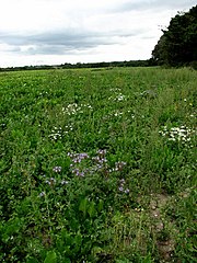
English: Heading east on the edge of a sugar beet field. The blue flowering plant in the foreground is Lacy Phacelia (Latin name: Phacelia tanacetifolia). It is native to the arid southwest region of the USA and Mexico, but has been introduced to Europe, where it is extensively used both as a cover crop and as bee forage. In agriculture, phacelia is often used as so-called green manure crop. Green manure crops are sown and allowed to grow until the land is needed again or until the plants have reached a certain growth stage. They are then cut down and ploughed into the soil. Left to decompose, they release vital plant nutrients back into the soil, hence fertilizing it. Phacelia is also used as an intercrop with corn and sugar beet or as an undercrop in orchards. For a more detailed view see > 558485 |
||
| Date | |||
| Source | geograph.org.uk | ||
| Author | Evelyn Simak | ||
| Permission (Reusing this file) |
This file is licensed under the Creative Commons Attribution-Share Alike 2.0 Generic license. Attribution: Evelyn Simak
|
||
| Attribution (required by the license) | Evelyn Simak / Heading east on the edge of a sugar beet field / | ||

_-_geograph.org.uk_-_558485.jpg)
| Camera location | | View this and other nearby images on: OpenStreetMap |
|---|
_heading:90.00&language=en)
| Object location | | View this and other nearby images on: OpenStreetMap |
|---|
_heading:90.00&language=en)
- Remove redundant categories and try to put this image in the most specific category/categories
- Remove this template
- The location categories are based on information from this geonames tool and this OpenStreetMap tool combined with a database. You can also have a look at this tool from mysociety.
- The topic category from Geograph was Fields (find similar images at Geograph)
File history
Click on a date/time to view the file as it appeared at that time.
| Date/Time | Thumbnail | Dimensions | User | Comment | |
|---|---|---|---|---|---|
| current | 03:07, 6 February 2011 | | 480 × 640 (93 KB) | GeographBot (talk | contribs) | == {{int:filedesc}} == {{Information |description={{en|1=Heading east on the edge of a sugar beet field The blue flowering plant in the foreground is Lacy Phacelia (Latin name: Phacelia tanacetifolia). It is native to the arid southwest region of the USA |
You cannot overwrite this file.
File usage on Commons
There are no pages that use this file.