File:Heard Island.jpg

Size of this preview: 800 × 413 pixels. Other resolutions: 320 × 165 pixels | 640 × 331 pixels | 1,280 × 661 pixels.
Original file (1,280 × 661 pixels, file size: 60 KB, MIME type: image/jpeg)
Captions
Captions
Add a one-line explanation of what this file represents
Summary edit
| Description |
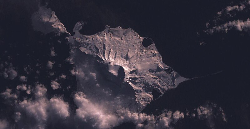
English: Heard Island |
| Date | 3 February 2005 (upload date) |
| Source | Satellite imagery taken by screenshot from NASA World Wind software |
| Author | NASA |
| Object location | | View this and other nearby images on: OpenStreetMap |
|---|
Licensing edit
| This image is in the public domain because it is a screenshot from NASA’s globe software World Wind using a public domain layer, such as Blue Marble, MODIS, Landsat, SRTM, USGS or GLOBE.
|
 |
File history
Click on a date/time to view the file as it appeared at that time.
| Date/Time | Thumbnail | Dimensions | User | Comment | |
|---|---|---|---|---|---|
| current | 05:40, 3 February 2005 | | 1,280 × 661 (60 KB) | Dysprosia~commonswiki (talk | contribs) | Heard Island, from NASA World Wind, {{PD-USGov-NASA}}, worldwind://goto/world=Earth&lat=-53.1084289550781&lon=73.5561141967773&view=0.609335660934448 |
You cannot overwrite this file.
File usage on Commons
The following 4 pages use this file:
File usage on other wikis
The following other wikis use this file:
- Usage on af.wikipedia.org
- Usage on ar.wikipedia.org
- Usage on ast.wikipedia.org
- Usage on az.wikipedia.org
- Usage on be.wikipedia.org
- Usage on ca.wikipedia.org
- Usage on ceb.wikipedia.org
- Usage on ckb.wikipedia.org
- Usage on cs.wikipedia.org
- Usage on cy.wikipedia.org
- Usage on de.wikipedia.org
- Usage on de.wikivoyage.org
- Usage on en.wikipedia.org
- Usage on en.wikivoyage.org
- Usage on eo.wikipedia.org
- Usage on es.wikipedia.org
- Usage on fa.wikipedia.org
- Usage on fi.wikipedia.org
- Usage on frr.wikipedia.org
- Usage on fr.wikipedia.org
- Usage on fr.wikivoyage.org
- Usage on fy.wikipedia.org
- Usage on gl.wikipedia.org
- Usage on he.wikipedia.org
- Usage on he.wikivoyage.org
- Usage on hr.wikipedia.org
- Usage on hu.wikipedia.org
- Usage on id.wikipedia.org
View more global usage of this file.