File:Heartland.png
No higher resolution available.
Heartland.png (752 × 449 pixels, file size: 43 KB, MIME type: image/png)
Captions
Captions
Add a one-line explanation of what this file represents
Summary edit
| Description |
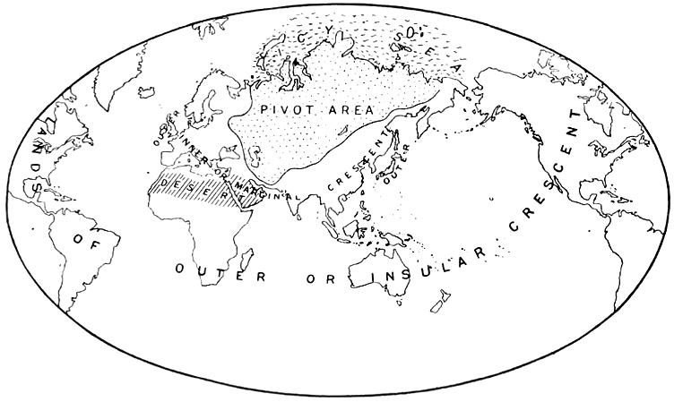
English: A map from Halford Mackinder's The Geographical Pivot of History
Nederlands: Het door Mackinder aangewezen Heartland, ook wel The Geographical Pivot of History genoemd. |
| Date | 18 March 2006 (original upload date) |
| Source | "The Geographical Pivot of History", Geographical Journal 23, no. 4 (April 1904): 435.. Originally from nl.wikipedia; description page is/was here. |
| Author | Halford J. Mackinder |
Licensing edit
|
This work is in the public domain in its country of origin and other countries and areas where the copyright term is the author's life plus 70 years or fewer. This work is in the public domain in the United States because it was published (or registered with the U.S. Copyright Office) before January 1, 1929. | |
| This file has been identified as being free of known restrictions under copyright law, including all related and neighboring rights. | |
Original upload log edit
(All user names refer to nl.wikipedia)
- 2006-03-18 14:47 Marc-king 752×449×8 (65439 bytes) {{Bronvermelding}}
File history
Click on a date/time to view the file as it appeared at that time.
| Date/Time | Thumbnail | Dimensions | User | Comment | |
|---|---|---|---|---|---|
| current | 16:36, 22 February 2014 | | 752 × 449 (43 KB) | AnonMoos (talk | contribs) | increasing PNG compression |
| 14:39, 13 August 2010 |  | 752 × 449 (82 KB) | Beao (talk | contribs) | Transparent. | |
| 14:01, 2 February 2007 |  | 752 × 449 (64 KB) | Siebrand (talk | contribs) | {{Information |Description={{nl|Het door Mackinder aangewezen Heartland, ook wel The Geographical Pivot of History genoemd.}} |Source="The Geographical Pivot of History", Geographical Journal 23, no. 4 (April 1904): 435.. Originally from [http://nl.wikipe |
You cannot overwrite this file.
File usage on Commons
The following 3 pages use this file:
File usage on other wikis
The following other wikis use this file:
- Usage on ar.wikipedia.org
- Usage on bg.wikipedia.org
- Usage on bs.wikipedia.org
- Usage on cs.wikipedia.org
- Usage on da.wikipedia.org
- Usage on de.wikipedia.org
- Usage on el.wikipedia.org
- Usage on en.wikipedia.org
- Usage on en.wiktionary.org
- Usage on es.wikipedia.org
- Usage on fi.wikipedia.org
- Usage on he.wikipedia.org
- Usage on hi.wikipedia.org
- Usage on hy.wikipedia.org
- Usage on it.wikipedia.org
- Usage on ja.wikipedia.org
- Usage on ka.wikipedia.org
- Usage on nl.wikipedia.org
- Usage on no.wikipedia.org
- Usage on pl.wikipedia.org
- Usage on pt.wikipedia.org
- Usage on ru.wikipedia.org
- Usage on sv.wikipedia.org
- Usage on uk.wikipedia.org
- Usage on www.wikidata.org
- Usage on zh.wikipedia.org