File:Heerlerheidezilverzand.png

Size of this preview: 645 × 600 pixels. Other resolutions: 258 × 240 pixels | 516 × 480 pixels | 826 × 768 pixels | 1,101 × 1,024 pixels | 2,203 × 2,048 pixels | 2,850 × 2,650 pixels.
Original file (2,850 × 2,650 pixels, file size: 3.88 MB, MIME type: image/png)
Captions
Captions
Add a one-line explanation of what this file represents
Summary edit
| Description |
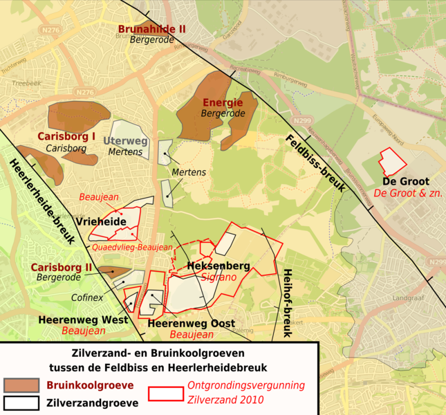
English: Lignite and quartzsand quarries between the Feldbiss and Heerlerheide faults, Limburg, The Netherlands
Nederlands: Bruinkool- en zilverzandgroeven tussen de Feldbiss en Heerlerheidebreuk, Limburg, Nederland |
| Date | |
| Source | Own work |
| Author | Hans Erren |
Sources:
- OpenStreetmap
- Geologische kaart Zuid-Limburg Prekwartair RGD 1984
- Geologische kaart Zuid-Limburg Oppervlakte RGD 1988
- Ontgrondingsvergunningen provincie Limburg
- Startnotitie Milieu-effectrapportage Zilverzandwinning ter plaatse van de Steenberg Oranje Nassau IV Gemeente Heerlen
- Actueel Hoogtebestand Nederland
Licensing edit
I, the copyright holder of this work, hereby publish it under the following licenses:
This file is licensed under the Creative Commons Attribution-Share Alike 3.0 Unported license.
- You are free:
- to share – to copy, distribute and transmit the work
- to remix – to adapt the work
- Under the following conditions:
- attribution – You must give appropriate credit, provide a link to the license, and indicate if changes were made. You may do so in any reasonable manner, but not in any way that suggests the licensor endorses you or your use.
- share alike – If you remix, transform, or build upon the material, you must distribute your contributions under the same or compatible license as the original.

|
Permission is granted to copy, distribute and/or modify this document under the terms of the GNU Free Documentation License, Version 1.2 or any later version published by the Free Software Foundation; with no Invariant Sections, no Front-Cover Texts, and no Back-Cover Texts. A copy of the license is included in the section entitled GNU Free Documentation License. |
You may select the license of your choice.
File history
Click on a date/time to view the file as it appeared at that time.
| Date/Time | Thumbnail | Dimensions | User | Comment | |
|---|---|---|---|---|---|
| current | 15:37, 26 February 2011 | | 2,850 × 2,650 (3.88 MB) | Hans Erren (talk | contribs) | Lignite concession boundaries modified after Topographic map of 1925 |
| 21:26, 23 February 2011 |  | 2,850 × 2,650 (3.87 MB) | Hans Erren (talk | contribs) | Sand concession boundaries modified after Natura 2000 Concept-Beheerplan Brunssummerheide 9 augustus 2009 Provincie Limburg fig 5.6 | |
| 23:12, 4 February 2011 |  | 2,850 × 2,650 (3.88 MB) | Hans Erren (talk | contribs) | {{Information |Description ={{en|1=Lignite and quartzsand quarries between the Feldbiss and Heerlerheide faults, Limburg, The Netherlands}} {{nl|1=Bruinkool- en zilverzandgroeven tussen de Feldbiss en Heerlerheidebreuk, Limburg, Nederland}} |Source |
You cannot overwrite this file.
File usage on Commons
There are no pages that use this file.
File usage on other wikis
The following other wikis use this file:
- Usage on da.wikipedia.org
- Usage on nl.wikipedia.org