File:Heng San Teng 1.png

Size of this preview: 800 × 524 pixels. Other resolutions: 320 × 209 pixels | 640 × 419 pixels | 1,054 × 690 pixels.
Original file (1,054 × 690 pixels, file size: 1.58 MB, MIME type: image/png)
Captions
Captions
Add a one-line explanation of what this file represents
Summary
edit
| Description |
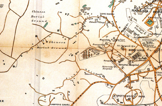
Deutsch: Karte von Singapur von 1913 mit der Umgebung des Tempels Heng San Teng (im unteren Bereich, etwa mittig, als Chinese Temple verzeichnet) und der Friedhöfe Tiong Lama und Tiong Bahru; das SGH (Singapore General Hospital) mit seinen Einrichtungen ist ebenfalls zu sehen, wie zahlreiche weitere Friedhöfe. |
| Date | |
| Source | https://libmaps.nus.edu.sg. |
| Author |
Fraser and Neave Limited 1913. Map of Singapore Showing The Principal Residences and Places of Interest, 1:12,672. Singapore: Fraser and Neave Limited. In: "Historical Maps of Singapore, digitised by Department of Geography, National University of Singapore." https://libmaps.nus.edu.sg. Rights and Restrictions: None (see https://libmaps.nus.edu.sg/metadata/1913.xml) derivated by -jkb-: cropped, converted to png |
Licensing
edit
| This work has been released into the public domain by its author, author. This applies worldwide. In some countries this may not be legally possible; if so: author grants anyone the right to use this work for any purpose, without any conditions, unless such conditions are required by law.
|
Rights and Restrictions: None (see https://libmaps.nus.edu.sg/metadata/1913.xml)
File history
Click on a date/time to view the file as it appeared at that time.
| Date/Time | Thumbnail | Dimensions | User | Comment | |
|---|---|---|---|---|---|
| current | 17:17, 19 August 2018 | | 1,054 × 690 (1.58 MB) | -jkb- (talk | contribs) | User created page with UploadWizard |
You cannot overwrite this file.
File usage on Commons
The following page uses this file:
File usage on other wikis
The following other wikis use this file:
- Usage on de.wikipedia.org