File:Hiroshima City Map 1945.jpg
Size of this preview: 703 × 599 pixels. Other resolutions: 282 × 240 pixels | 563 × 480 pixels | 901 × 768 pixels | 1,201 × 1,024 pixels | 2,402 × 2,048 pixels | 5,000 × 4,263 pixels.
Original file (5,000 × 4,263 pixels, file size: 6.15 MB, MIME type: image/jpeg)
Captions
Captions
Add a one-line explanation of what this file represents
Summary edit
| Description |
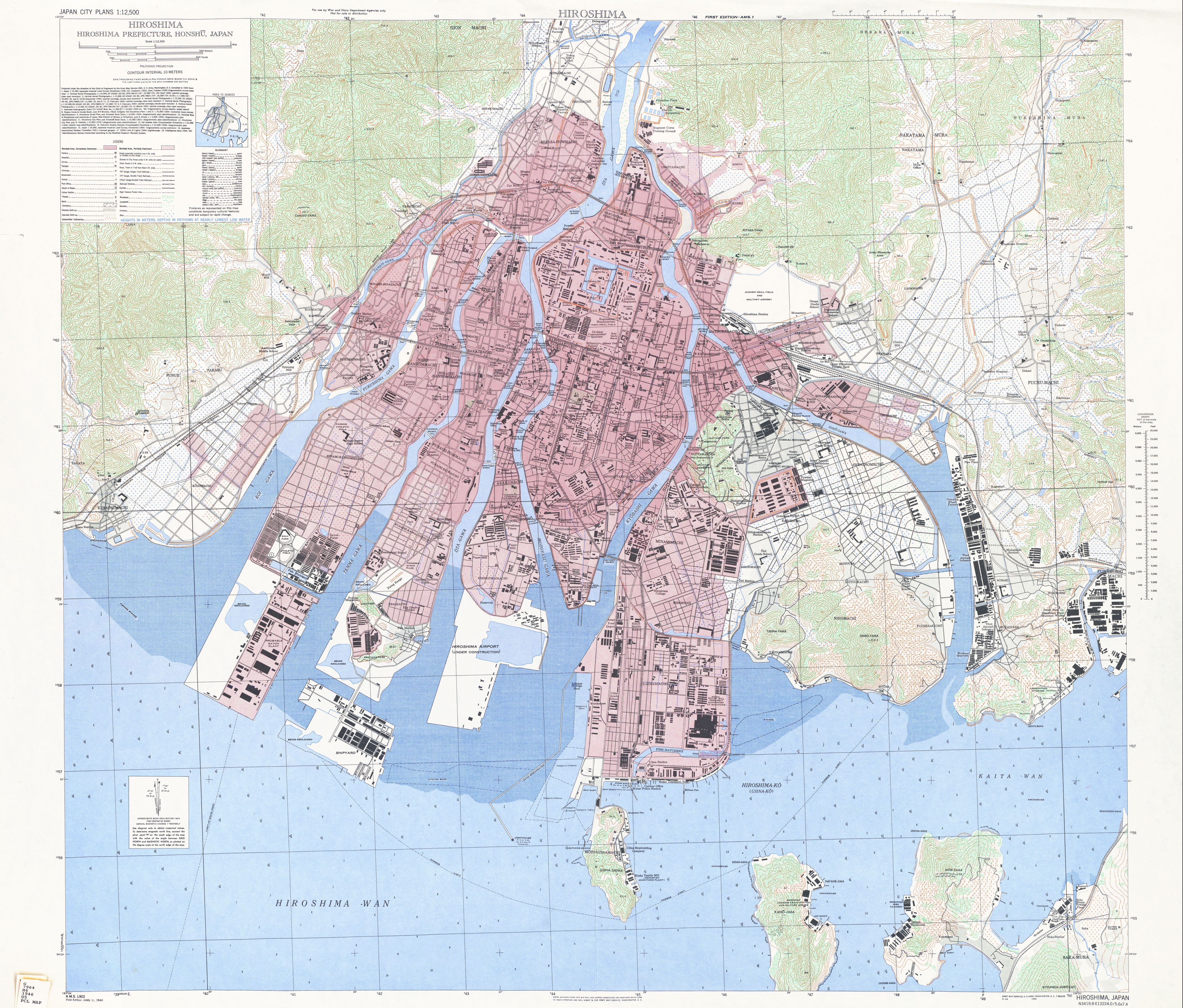
日本語: 1945年アメリカ軍作成の旧広島市の地図。1930年代の大日本帝国陸軍の陸地測量部他の各種刊行物と1945年の米軍による航空写真をもとに米国陸軍が作成した地図で原爆による被災状況が記載されている。赤い斜線(濃い赤)の地域が全壊地域、赤い点(薄い赤)の地域が半壊地域である。地図の升目は1000ヤード(914.4メートル)である。 |
| Date | |
| Source |
Japan City Plans , Perry-Castañeda Library Map Collection , University of Texas Libraries |
| Author | U.S. Army Map Service, 1945-1946 |
Licensing edit
This work is in the public domain in the United States because it is a work prepared by an officer or employee of the United States Government as part of that person’s official duties under the terms of Title 17, Chapter 1, Section 105 of the US Code.
Note: This only applies to original works of the Federal Government and not to the work of any individual U.S. state, territory, commonwealth, county, municipality, or any other subdivision. This template also does not apply to postage stamp designs published by the United States Postal Service since 1978. (See § 313.6(C)(1) of Compendium of U.S. Copyright Office Practices). It also does not apply to certain US coins; see The US Mint Terms of Use.
|
 | |
| This file has been identified as being free of known restrictions under copyright law, including all related and neighboring rights. | ||
File history
Click on a date/time to view the file as it appeared at that time.
| Date/Time | Thumbnail | Dimensions | User | Comment | |
|---|---|---|---|---|---|
| current | 14:56, 7 November 2013 | | 5,000 × 4,263 (6.15 MB) | M9106TB (talk | contribs) | User created page with UploadWizard |
You cannot overwrite this file.
File usage on Commons
There are no pages that use this file.
File usage on other wikis
The following other wikis use this file:
- Usage on ja.wikipedia.org
- 横川駅 (広島県)
- 広島駅
- 広島電鉄
- 向洋駅
- 西広島駅
- 広島県総合グランドメインスタジアム
- 広島空港
- 広島電鉄本線
- 広島電鉄宇品線
- 宇品線
- 広電西広島駅
- 広島城
- 草津南駅
- 広島港
- 広島西飛行場
- 東洋工業サッカー部
- 舟入 (広島市)
- 広島市への原子爆弾投下
- 草津 (広島市)
- 広島文理科大学 (旧制)
- 広島市立工業専門学校 (旧制)
- 広島女子高等師範学校
- 広島師範学校
- 広島医科大学
- 相生通り
- 今西和男
- 吉島 (広島市)
- 中島町 (広島市)
- 白島 (広島市)
- 千田町 (広島市)
- 国泰寺町 (広島市)
- 観音 (広島市)
- 東雲 (広島市)
- 霞 (広島市)
- 広島東照宮
- 仁保 (広島市)
- 本浦 (広島市)
- 広島市役所
- 中山 (広島市)
- 広島平野
- えびす通り商店街
- この世界の片隅に
- マツダ
- 広島市
- 工兵橋
- 観光橋
- 比治山橋
- 御幸橋 (広島市)
- 福島橋 (広島市)
- 己斐橋
View more global usage of this file.