File:Hispaniola.png

Size of this preview: 800 × 355 pixels. Other resolutions: 320 × 142 pixels | 640 × 284 pixels | 1,024 × 455 pixels | 1,280 × 569 pixels | 3,510 × 1,559 pixels.
Original file (3,510 × 1,559 pixels, file size: 4.1 MB, MIME type: image/png)
Captions
Captions
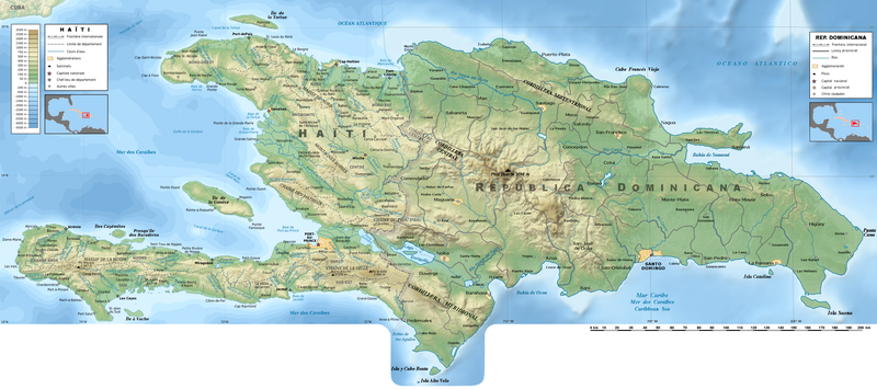
Map of Hispaniola Island (French & Spanish).
Summary edit
| Description |
English: Map of Hispaniola Island with Haïti and the Dominican republic. |
||
| Date | |||
| Source | Rémi Kaupp's File:Haiti_topographic_map-fr.png and File:Dominican_Republic_relief_location_map.jpg enriched since several maps available. | ||
| Author | Rémi Kaupp and Claude Zygiel | ||
| Permission (Reusing this file) |
|
Licensing edit
I, the copyright holder of this work, hereby publish it under the following license:
This file is licensed under the Creative Commons Attribution-Share Alike 4.0 International license.
- You are free:
- to share – to copy, distribute and transmit the work
- to remix – to adapt the work
- Under the following conditions:
- attribution – You must give appropriate credit, provide a link to the license, and indicate if changes were made. You may do so in any reasonable manner, but not in any way that suggests the licensor endorses you or your use.
- share alike – If you remix, transform, or build upon the material, you must distribute your contributions under the same or compatible license as the original.
File history
Click on a date/time to view the file as it appeared at that time.
| Date/Time | Thumbnail | Dimensions | User | Comment | |
|---|---|---|---|---|---|
| current | 10:07, 4 February 2023 | | 3,510 × 1,559 (4.1 MB) | Claude Zygiel (talk | contribs) | Uploaded own work with UploadWizard |
You cannot overwrite this file.
File usage on Commons
The following 4 pages use this file:
File usage on other wikis
The following other wikis use this file:
- Usage on ar.wikipedia.org
- Usage on ba.wikipedia.org
- Usage on ca.wikipedia.org
- Usage on fr.wikipedia.org
- Usage on hy.wikipedia.org
- Usage on lb.wikipedia.org
- Usage on nl.wikipedia.org
- Usage on tg.wikipedia.org
- Usage on www.wikidata.org