File:Historic American Buildings Survey Photographed by Henry F. Withey May, 1937 BARRACKS BUILDING -1, VIEW FROM NORTHWEST - Fort Tejon, Barracks Number One, Highway 99, Lebec, HABS CAL,15-LEBEC.V,1A-3.tif

Size of this JPG preview of this TIF file: 800 × 516 pixels. Other resolutions: 320 × 207 pixels | 640 × 413 pixels | 1,024 × 661 pixels | 1,280 × 826 pixels | 2,560 × 1,652 pixels | 5,000 × 3,227 pixels.
Original file (5,000 × 3,227 pixels, file size: 15.39 MB, MIME type: image/tiff)
Captions
Captions
Add a one-line explanation of what this file represents
Summary edit
|
This is an image of a place or building that is listed on the National Register of Historic Places in the United States of America. Its reference number is 71000140. |
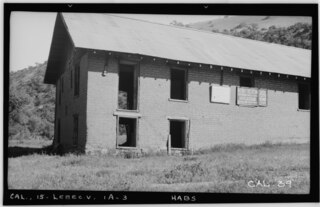
| Historic American Buildings Survey Photographed by Henry F. Withey May, 1937 BARRACKS BUILDING -1, VIEW FROM NORTHWEST - Fort Tejon, Barracks Number One, Highway 99, Lebec, Kern County, CA | ||||
|---|---|---|---|---|
| Photographer | ||||
| Title |
Historic American Buildings Survey Photographed by Henry F. Withey May, 1937 BARRACKS BUILDING -1, VIEW FROM NORTHWEST - Fort Tejon, Barracks Number One, Highway 99, Lebec, Kern County, CA |
|||
| Description |
Adobe Barracks Number One ruins at Fort Tejon State Historic Park — at Tejon Pass (Hwy 99, I−5) in the Tehachapi Mountains, southern Kern County, California.
|
|||
| Depicted place | California; Kern County; Lebec | |||
| Date | 1937 | |||
| Dimensions | 4 x 5 in. | |||
| Current location |
Library of Congress Prints and Photographs Division Washington, D.C. 20540 USA http://hdl.loc.gov/loc.pnp/pp.print |
|||
| Accession number |
HABS CAL,15-LEBEC.V,1A-3 |
|||
| Credit line |
|
|||
| Source | https://www.loc.gov/pictures/item/ca0190.photos.011561p | |||
| Permission (Reusing this file) |
|
|||

| Camera location | | View this and other nearby images on: OpenStreetMap |
|---|
File history
Click on a date/time to view the file as it appeared at that time.
| Date/Time | Thumbnail | Dimensions | User | Comment | |
|---|---|---|---|---|---|
| current | 05:25, 2 July 2014 |  | 5,000 × 3,227 (15.39 MB) | Fæ (talk | contribs) | GWToolset: Creating mediafile for Fæ. HABS 1 July 2014 (201:300) |
You cannot overwrite this file.
File usage on Commons
The following page uses this file: