File:History of NATO enlargement el.png
Size of this preview: 600 × 600 pixels. Other resolutions: 240 × 240 pixels | 480 × 480 pixels | 732 × 732 pixels.
Original file (732 × 732 pixels, file size: 194 KB, MIME type: image/png)
Captions
Captions
Add a one-line explanation of what this file represents
Summary edit
| Description |
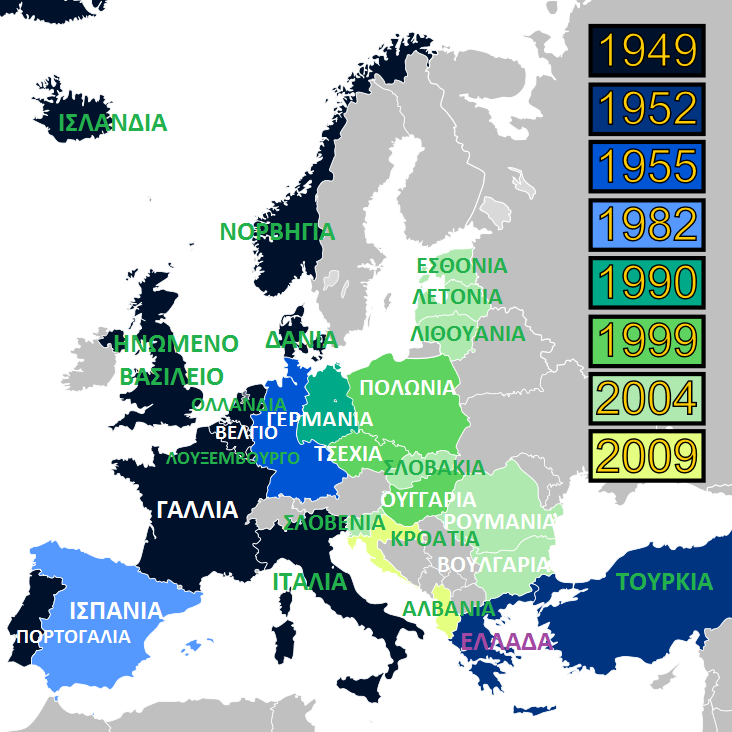
English: Map of NATO historic enlargement in Europe. Čeština: Mapa rozšiřování NATO v Evropě. Dansk: Kort over NATOs historiske udvidelser i Europa. |
| Date | 21 April 2014 (original upload date) |
| Source | File:History of NATO enlargement.svg |
| Author | Original: User:Patrickneil, based off of Image:EU1976-1995.svg by glentamara - Translated: Cretan2014 |
Licensing edit

|
Permission is granted to copy, distribute and/or modify this document under the terms of the GNU Free Documentation License, Version 1.2 or any later version published by the Free Software Foundation; with no Invariant Sections, no Front-Cover Texts, and no Back-Cover Texts. A copy of the license is included in the section entitled GNU Free Documentation License. |
Original upload log edit
The original description page was here. All following user names refer to el.wikipedia.
| Date/Time | Dimensions | User | Comment |
|---|---|---|---|
| 2014-04-21 17:54 | 732×732× (199083 bytes) | Cretan2014 | {{Πληροφορίες εικόνας |Περιγραφή= |Πηγή= |Ημερομηνία= |Δημιουργός= |Άδεια χρήσης= }} |
File history
Click on a date/time to view the file as it appeared at that time.
| Date/Time | Thumbnail | Dimensions | User | Comment | |
|---|---|---|---|---|---|
| current | 09:30, 20 October 2016 | | 732 × 732 (194 KB) | MARKELLOS (talk | contribs) | Transferred from el.wikipedia |
You cannot overwrite this file.
File usage on Commons
There are no pages that use this file.