File:Holly Hill 1937.jpg

Size of this preview: 800 × 559 pixels. Other resolutions: 320 × 224 pixels | 640 × 447 pixels | 1,024 × 715 pixels | 1,280 × 894 pixels | 2,560 × 1,789 pixels | 4,732 × 3,306 pixels.
Original file (4,732 × 3,306 pixels, file size: 1.58 MB, MIME type: image/jpeg)
Captions
Captions
Add a one-line explanation of what this file represents
|
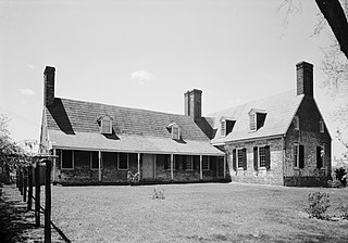
This is an image of a place or building that is listed on the National Register of Historic Places in the United States of America. Its reference number is 71000367. |
| Camera location | | View this and other nearby images on: OpenStreetMap |
|---|
Summary edit
| Description |
English: Eastern side of Holly Hill, located southeast of Friendship off Maryland Route 631 in Anne Arundel County, Maryland, United States. Built in 1667, it is listed on the National Register of Historic Places. |
|||||||||||||||||||||||
| Date | ||||||||||||||||||||||||
| Source |
|
|||||||||||||||||||||||
| Author |
|
|||||||||||||||||||||||
| Permission (Reusing this file) |
|
|||||||||||||||||||||||


|
This image is available from the United States Library of Congress's Prints and Photographs division
under the digital ID hhh.md0412. This tag does not indicate the copyright status of the attached work. A normal copyright tag is still required. See Commons:Licensing.
|
File history
Click on a date/time to view the file as it appeared at that time.
| Date/Time | Thumbnail | Dimensions | User | Comment | |
|---|---|---|---|---|---|
| current | 17:18, 21 February 2010 | | 4,732 × 3,306 (1.58 MB) | Nyttend (talk | contribs) | {{Location|38|43|30|N|76|33|59|W}} {{Information |Description={{en|Eastern side of {{w|Holly Hill (Friendship, Maryland)|Holly Hill}}, located southeast of {{w|Friendship, Maryland|Friendship}} off {{w|Maryland Route 631}} in {{w|Anne Arundel County, Mary |
You cannot overwrite this file.
File usage on Commons
The following page uses this file:
File usage on other wikis
The following other wikis use this file:
- Usage on en.wikipedia.org
- Usage on www.wikidata.org