File:Hood Canal drumlins 03 perspective-view hillshade color (51149169842).jpg

Original file (5,000 × 2,710 pixels, file size: 10.97 MB, MIME type: image/jpeg)
Captions
Captions
Summary edit
.jpg&action=edit§ion=1)
| Description |
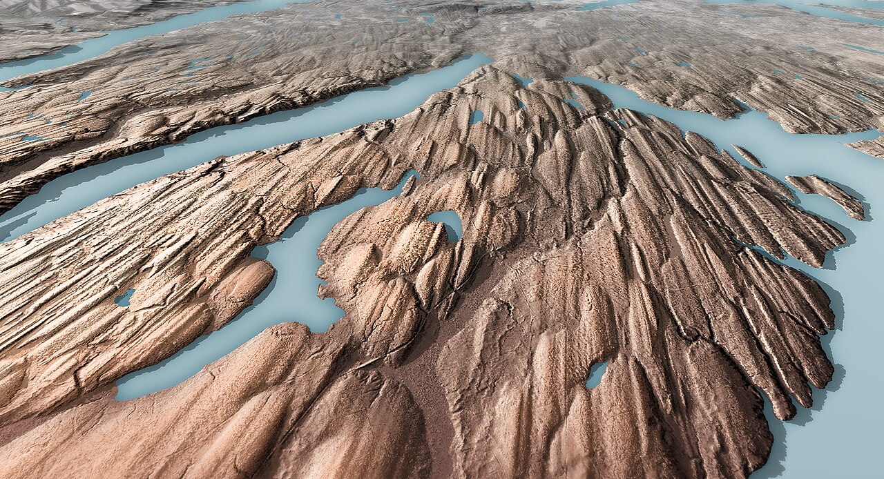
Lidar-derived image of glacial drumlins near the Hood Canal. Drumlins (or fluted ridges) are geologic features where movement of the ice sheet smooths glacial sediment into elongated teardrop shapes. Drumlins align in the direction of the ice flow and are evident across most of the Puget Lowland. Image by Daniel E. Coe, Washington Geological Survey This image is also part of a series-click the links for the series images: <a href="https://www.flickr.com/photos/wastatednr/51149845461/in/album-72157719067545884/">Image 1 Hood Canal drumlins hillshade color</a> <a href="https://www.flickr.com/photos/wastatednr/51149846466/in/album-72157719067545884/">Image 2 Hood Canal drumlins photo</a> <a href="https://www.flickr.com/photos/wastatednr/51149169842/in/album-72157719067545884/">Image 3 Hood Canal drumlins perspective-view hillshade color</a> Learn and see more: <a href="https://wa100.dnr.wa.gov/puget-lowland/hood-canal" rel="noreferrer nofollow">WA100 Hood Canal page</a> <a href="https://www.flickr.com/photos/wastatednr/51132063848/in/album-72157718994052478/">Glacial Landforms of the Puget Lowland map</a> <a href="https://wa100.dnr.wa.gov/puget-lowland/glacial-landforms" rel="noreferrer nofollow">WA100 Glacial Landforms page</a> <a href="https://www.dnr.wa.gov/lidar" rel="noreferrer nofollow">WGS Lidar page</a> <a href="https://wadnr.maps.arcgis.com/apps/Cascade/index.html?appid=36b4887370d141fcbb35392f996c82d9" rel="noreferrer nofollow">The Bare Earth lidar story map</a> <a href="https://lidarportal.dnr.wa.gov/" rel="noreferrer nofollow">Washington Lidar Portal</a> You may use this image for any purpose, commercial or non-commercial, with or without modification, as long as you attribute us. For attribution please use ‘Image from the Washington Geological Survey (Washington State DNR)’ if it’s a direct reproduction, or ‘Image modified from the Washington Geological Survey (Washington State DNR)’ if there has been some modification. For more information, see the linked Creative Commons Attribution-ShareAlike license. |
| Date | |
| Source | Hood Canal drumlins 03 perspective-view hillshade color |
| Author | Washington DNR |
| Camera location | | View this and other nearby images on: OpenStreetMap |
|---|
.jpg¶ms=047.361153_N_-122.982330_E_globe:Earth_type:camera_source:Flickr_&language=en)
Licensing edit
.jpg&action=edit§ion=2)
- You are free:
- to share – to copy, distribute and transmit the work
- to remix – to adapt the work
- Under the following conditions:
- attribution – You must give appropriate credit, provide a link to the license, and indicate if changes were made. You may do so in any reasonable manner, but not in any way that suggests the licensor endorses you or your use.
- share alike – If you remix, transform, or build upon the material, you must distribute your contributions under the same or compatible license as the original.
| This image was originally posted to Flickr by Washington State Department of Natural Resources at https://flickr.com/photos/35433815@N08/51149169842. It was reviewed on 27 May 2023 by FlickreviewR 2 and was confirmed to be licensed under the terms of the cc-by-sa-2.0. |
File history
Click on a date/time to view the file as it appeared at that time.
| Date/Time | Thumbnail | Dimensions | User | Comment | |
|---|---|---|---|---|---|
| current | 08:19, 27 May 2023 | | 5,000 × 2,710 (10.97 MB) | Geo Swan (talk | contribs) | Transferred from Flickr via #flickr2commons |
You cannot overwrite this file.
File usage on Commons
There are no pages that use this file.
.jpg&oldid=856526149)