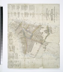
File:Hooker's new pocket plan of the city of New York - compiled and surveyed by William Hooker, A.C.S.A., hydrographer and engraver. NYPL489826.tiff

Size of this JPG preview of this TIF file: 524 × 600 pixels. Other resolutions: 210 × 240 pixels | 419 × 480 pixels | 671 × 768 pixels | 895 × 1,024 pixels | 1,790 × 2,048 pixels | 4,952 × 5,667 pixels.
Original file (4,952 × 5,667 pixels, file size: 80.29 MB, MIME type: image/tiff)
Captions
Captions
Add a one-line explanation of what this file represents
Summary
edit| Description | Hooker's new pocket plan of the city of New York / compiled and surveyed by William Hooker, A.C.S.A., hydrographer and engraver.; Maps of New York City and State / New York City / Manhattan | |||||||||||||||||||||||
| Notes | Covers Manhattan south of 15th street on the west and south of 31st street on the east. ''Note 2.'') Shows ward boundaries. ''Note 3.'') "Drawn, engraved, printed, published and sold by W. Hooker, instrument maker and chart seller to the U.S. Navy, and agent for the Nautical Store, 202, Water Street, where all the nautical works of Edm. M. Blunt are published and by him inspected." ''Note 4.'') "Entered according to act of Congress, the 27th day of March, 1824, by Wm. Hooker, of the state of N. York." ''Note 5.'') Includes lists of distributors, churches, markets, banks, newspapers, colleges, theaters, gardens, and public buildings. ''Note 6.'') National Endowment for the Humanities Grant for Access to Early Maps of the Middle Atlantic Seaboard. | |||||||||||||||||||||||
| Item physical description | 1 map : hand col. ; 32 x 40 cm. | |||||||||||||||||||||||
| Catalogue call number | Map Div. 01-313 | |||||||||||||||||||||||
| Standard reference | Haskell, D.C. Manhattan maps, 701 | |||||||||||||||||||||||
| Date | ||||||||||||||||||||||||
| Source |
http://digitalgallery.nypl.org/nypldigital/dgkeysearchdetail.cfm?imageID=489826
|
|||||||||||||||||||||||
| Author | Hooker, William -- Engraver | |||||||||||||||||||||||
| Permission (Reusing this file) |
From The Lionel Pincus and Princess Firyal Map Division. http://maps.nypl.org
|
|||||||||||||||||||||||
| Location | Stephen A. Schwarzman Building / The Lionel Pincus and Princess Firyal Map Division | |||||||||||||||||||||||
| Digital item published | 2-28-2005; updated 5-16-2012 | |||||||||||||||||||||||
| Digital ID | 489826 | |||||||||||||||||||||||

The making of this file was supported by Wikimedia UK.
To see other files made with the support of Wikimedia UK, please see the category Supported by Wikimedia UK.
|
File history
Click on a date/time to view the file as it appeared at that time.
| Date/Time | Thumbnail | Dimensions | User | Comment | |
|---|---|---|---|---|---|
| current | 10:57, 29 April 2014 |  | 4,952 × 5,667 (80.29 MB) | Fæ (talk | contribs) | GWToolset:: Creating mediafile for Fæ. Tranche 3 5495-7474 (2) |
You cannot overwrite this file.
File usage on Commons
There are no pages that use this file.