File:Hornád River - location and watershed map.svg

Size of this PNG preview of this SVG file: 800 × 430 pixels. Other resolutions: 320 × 172 pixels | 640 × 344 pixels | 1,024 × 551 pixels | 1,280 × 689 pixels | 2,560 × 1,377 pixels | 4,680 × 2,518 pixels.
Original file (SVG file, nominally 4,680 × 2,518 pixels, file size: 119 KB)
Captions
Captions
Add a one-line explanation of what this file represents
| Description |
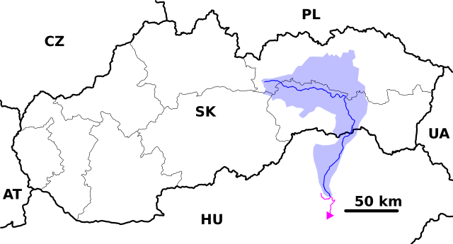
English: Location and watershed map of the Hernád River in Slovakia, ready for the Geobox template, calibrated at en:Template:Geobox locator Slovakia |
| Date | (UTC) |
| Source | |
| Author |
|
| This is a retouched picture, which means that it has been digitally altered from its original version. Modifications: adding Hernád river. The original can be viewed here: Hron River - location and watershed map.svg:
|
I, the copyright holder of this work, hereby publish it under the following license:
This file is licensed under the Creative Commons Attribution-Share Alike 2.5 Generic license.
- You are free:
- to share – to copy, distribute and transmit the work
- to remix – to adapt the work
- Under the following conditions:
- attribution – You must give appropriate credit, provide a link to the license, and indicate if changes were made. You may do so in any reasonable manner, but not in any way that suggests the licensor endorses you or your use.
- share alike – If you remix, transform, or build upon the material, you must distribute your contributions under the same or compatible license as the original.
Original upload log edit
This image is a derivative work of the following images:
- File:Hron_River_-_location_and_watershed_map.svg licensed with Cc-by-sa-2.5
- 2007-11-01T21:21:15Z Caroig 4680x2518 (124280 Bytes) {{Information |Description={{en|Location and watershed map of the Hron River in Slovakia, ready for the [[:en:Template:Geobox|Geobox]] template, calibrated at [[:en:Template:Geobox locator Slovakia]]}} |Source=self-made |Date
Uploaded with derivativeFX
File history
Click on a date/time to view the file as it appeared at that time.
| Date/Time | Thumbnail | Dimensions | User | Comment | |
|---|---|---|---|---|---|
| current | 20:38, 16 May 2010 | | 4,680 × 2,518 (119 KB) | Piroska (talk | contribs) | {{Information |Description={{en|Location and watershed map of the Hron River in Slovakia, ready for the Geobox template, calibrated at en:Template:Geobox locator Slovakia}} |Source=*[[:File:Hron_River_-_location_and_watershed_ |
You cannot overwrite this file.
File usage on Commons
There are no pages that use this file.
File usage on other wikis
The following other wikis use this file:
- Usage on ar.wikipedia.org
- Usage on bg.wikipedia.org
- Usage on da.wikipedia.org
- Usage on de.wikipedia.org
- Usage on en.wikipedia.org
- Usage on fr.wikipedia.org
- Usage on hu.wikipedia.org
- Usage on no.wikipedia.org
- Usage on pl.wiktionary.org
- Usage on ru.wikipedia.org
- Usage on sk.wikipedia.org
- Usage on sr.wikipedia.org
- Usage on uk.wikipedia.org