File:Hua yi tu. LOC 2002626771.tif

Size of this JPG preview of this TIF file: 564 × 599 pixels. Other resolutions: 226 × 240 pixels | 452 × 480 pixels | 723 × 768 pixels | 964 × 1,024 pixels | 1,928 × 2,048 pixels | 4,848 × 5,149 pixels.
Original file (4,848 × 5,149 pixels, file size: 71.42 MB, MIME type: image/tiff)
Captions
Captions
Add a one-line explanation of what this file represents
Summary edit
| Description |
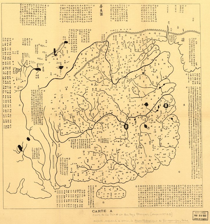
English: The "Map of China and the Barbarians" (Huayitu, Huayi Tu, or Hua–Yi Tu), a map of China during the Southern Song dynasty, originally engraved in the 7th year of the Fuchang Era (c. 1136) during the reign of Liu Yu (劉豫), the "emperor" of the Jin puppet state of Qi (齊). The Yellow River shown following its northern route, before floods transferred it south of Shandong to the mouth of the Huai. Covers the range from the Amur River and Great Wall in the north to Hainan in the south, from the Pamir Mountains in the west to Korea in the east. Shows mountains, rivers, lakes, and 400+ administrative place names in China. |
||
| Title | English: Map A: Map of China and the Barbarians (Huayitu).
中文:圖A:《華夷圖》, 图A:《华夷图》,Tu A: 《Huayi Tu》,T'u A: "Hua-i T'u".
Français : Carte A. Hua yi tu. |
||
| Shelf ID | G7820 1136 .H8 | ||
| Date |
English: c. 1903 rubbing of a map engraved in 1136
中文:阜昌七年 |
||
| Source | LOC, from Bulletin de l'Ecole Française d'Extrème Orient, Vol. 3, 1903, facing page 214, from stone rubbing of carving now in the Forest of Stone Steles Museum in Xi'an, China. | ||
| Author | Unknown author | ||
| Permission (Reusing this file) |
|
||
| Other versions |
|
||
| Location | China · Song Empire | ||
| Part of | American Memory · General Maps · Catalog · Geography And Map Division | ||
| Subject | Maps · Rubbing · China · Names, Geographical · Administrative And Political Divisions |


Licensing edit
|
This is a faithful photographic reproduction of a two-dimensional, public domain work of art. The work of art itself is in the public domain for the following reason:
The official position taken by the Wikimedia Foundation is that "faithful reproductions of two-dimensional public domain works of art are public domain".
This photographic reproduction is therefore also considered to be in the public domain in the United States. In other jurisdictions, re-use of this content may be restricted; see Reuse of PD-Art photographs for details. | ||||
File history
Click on a date/time to view the file as it appeared at that time.
| Date/Time | Thumbnail | Dimensions | User | Comment | |
|---|---|---|---|---|---|
| current | 05:15, 10 May 2018 |  | 4,848 × 5,149 (71.42 MB) | Fæ (talk | contribs) | LOC Maps https://www.loc.gov/item/2002626771/ #5234 |
You cannot overwrite this file.
File usage on Commons
The following 2 pages use this file: