File:Hurricane Bud - NASA Earth Observatory.jpg
Original file (720 × 720 pixels, file size: 143 KB, MIME type: image/jpeg)
Captions
Captions
Summary edit
| Description |
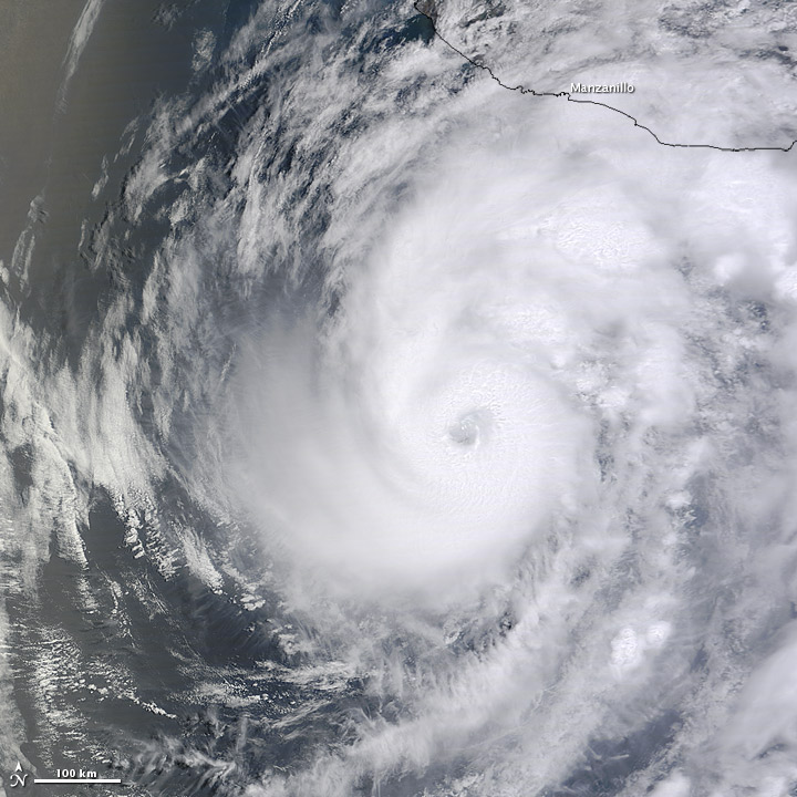
To download the full resolution and other files go to: earthobservatory.nasa.gov/NaturalHazards/view.php?id=7809... On May 25, 2012, Hurricane Bud was a Category 2 hurricane with sustained winds of 110 miles (175 kilometers) per hour. At 5:00 a.m. Pacific Daylight Time (PDT) on May 25, the U.S. National Hurricane Center (NHC) reported that Hurricane Bud was located roughly 105 miles (170 kilometers) southwest of Manzanillo, Mexico, and was headed toward Mexico’s southwestern coast. The Moderate Resolution Imaging Spectroradiometer (MODIS) on NASA’s Terra satellite captured this natural-color image around 11:15 a.m. PDT on May 24. Having organized since the previous day, Bud sported a distinct eye characteristic of strong storms. At 5:00 a.m. PDT on May 25, the NHC forecast that Bud could reach the coast of Mexico later that day. The NHC reported a hurricane warning for the coast of Mexico from Manzanillo to Cabo Corrientes, and a tropical storm warning from Punta San Telmo to east of Manzanillo. The NHC warned that Bud could produce a dangerous storm surge and several inches of rain, and urged residents to prepare quickly to protect lives and property. NASA image courtesy Jeff Schmaltz, MODIS Rapid Response Team, Goddard Space Flight Center. Caption by Michon Scott. View more from this event at earthobservatory.nasa.gov/NaturalHazards/event.php?id=780... The Earth Observatory's mission is to share with the public the images, stories, and discoveries about climate and the environment that emerge from NASA research, including its satellite missions, in-the-field research, and climate models. Like us on Facebook Follow us on Twitter Add us to your circles on Google+ |
| Date | |
| Source | Hurricane Bud |
| Author | NASA's Earth Observatory |
| Camera location | | View this and other nearby images on: OpenStreetMap |
|---|
Licensing edit
- You are free:
- to share – to copy, distribute and transmit the work
- to remix – to adapt the work
- Under the following conditions:
- attribution – You must give appropriate credit, provide a link to the license, and indicate if changes were made. You may do so in any reasonable manner, but not in any way that suggests the licensor endorses you or your use.
| This image was originally posted to Flickr by NASA Earth Observatory at https://www.flickr.com/photos/68824346@N02/7267896702. It was reviewed on 2 July 2012 by FlickreviewR and was confirmed to be licensed under the terms of the cc-by-2.0. |
File history
Click on a date/time to view the file as it appeared at that time.
| Date/Time | Thumbnail | Dimensions | User | Comment | |
|---|---|---|---|---|---|
| current | 17:02, 2 July 2012 | | 720 × 720 (143 KB) | Dzlinker (talk | contribs) | == {{int:filedesc}} == {{Information |Description=To download the full resolution and other files go to: [http://earthobservatory.nasa.gov/NaturalHazards/view.php?id=78094&src=flickr earthobservatory.nasa.gov/NaturalHazards/view.php?id=7809...] On May... |
You cannot overwrite this file.
File usage on Commons
The following page uses this file:
- File:Hurricane Bud (7267896702).jpg (file redirect)
.jpg&redirect=no)
File usage on other wikis
The following other wikis use this file:
- Usage on bn.wikipedia.org