File:Hurricane Earl 1998 tornadoes.gif

Size of this preview: 480 × 599 pixels. Other resolutions: 192 × 240 pixels | 384 × 480 pixels | 692 × 864 pixels.
Original file (692 × 864 pixels, file size: 20 KB, MIME type: image/gif)
Captions
Captions
Add a one-line explanation of what this file represents
Summary edit
| Description |
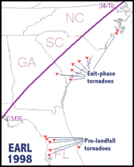
English: Preliminary mapping of tornadoes (filled triangles) associated with Hurricane Earl, September 1998. Thick line represents Earl's path, with approximate landfall and exit times pending final NHC "best track" |
| Date | |
| Source | http://www.spc.noaa.gov/publications/edwards/exittors.htm |
| Author | NOAA |
| Permission (Reusing this file) |
Public domain |
Licensing edit
This image is in the public domain because it contains materials that originally came from the U.S. National Oceanic and Atmospheric Administration, taken or made as part of an employee's official duties.
|
File history
Click on a date/time to view the file as it appeared at that time.
| Date/Time | Thumbnail | Dimensions | User | Comment | |
|---|---|---|---|---|---|
| current | 16:00, 19 July 2009 | | 692 × 864 (20 KB) | Cyclonebiskit (talk | contribs) | {{Information |Description={{en|1=Preliminary mapping of tornadoes (filled triangles) associated with Hurricane Earl, September 1998. Thick line represents Earl's path, with approximate landfall and exit times pending final NHC "best track"}} |Source=http |
You cannot overwrite this file.
File usage on Commons
There are no pages that use this file.
File usage on other wikis
The following other wikis use this file:
- Usage on en.wikipedia.org