File:Hutchings House.jpg

Size of this preview: 795 × 600 pixels. Other resolutions: 318 × 240 pixels | 637 × 480 pixels | 1,019 × 768 pixels | 1,280 × 965 pixels | 2,200 × 1,659 pixels.
Original file (2,200 × 1,659 pixels, file size: 2.24 MB, MIME type: image/jpeg)
Captions
Captions
Add a one-line explanation of what this file represents
Summary edit
| Description |
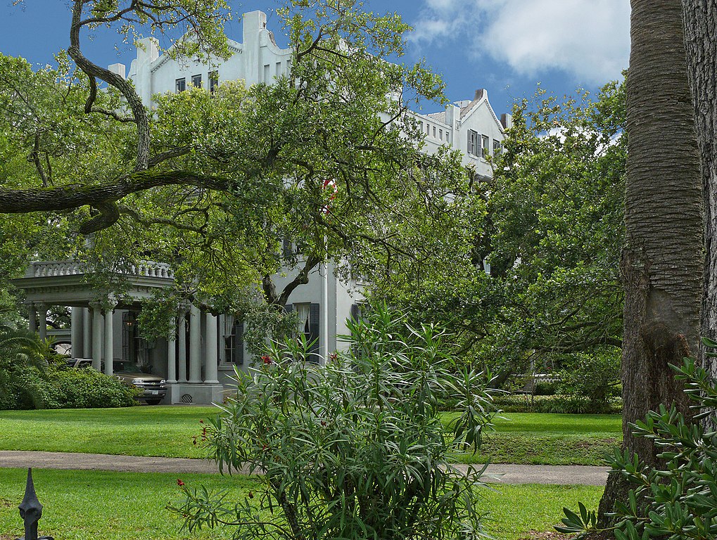
English: John Henry Hutchings was born in North Carolina in 1822. After living in New Orleans for several years, he moved to Galveston in 1845. Two years later he entered into a partnership with John Sealy to sell dry goods in Sabine Pass. They returned to Galveston in 1854 and set up shop with George Ball, selling dry goods and trading commissions; by 1856, the firm of Ball, Hutchings and Co. dealt exclusively in banking and commissions. Hutchings married Minnie Knox in 1856. Her uncle, Robert Mills, gave the couple five acres on Avenue O as a wedding gift, and they built one of early Galveston's rare brick houses. The bricks were fired on Mills' plantation in Brazoria. The house included a half-story schoolroom and teacher's quarters. During the Civil War, Ball, Hutchings & Co. established a shipping base in Matamoros, Mexico, to export cotton. John Henry Hutchings served as a commissioner of the Confederate State Court. The family left Galveston when it was evacuated but returned after the war's end. The house was damaged in an 1885 storm; renovations made by Nicholas Clayton over the next few years included the addition of a third level and the application of stucco to the exterior walls. Clayton designed and built the carriage house and completed other renovations by 1889. Raised after the 1900 storm, the house remained in the Hutchings family until 1926, when it was purchased by John Henry and Agnes Langben. The Langben heirs sold it to Sealy Hutchings, Jr., the grandson of John Henry and Minnie Hutchings, in 1946. He and his wife, Lucille, lived in the house the rest of their lives.
This house is a Recorded Texas Historic Landmark. The Hutchings House is across Avenue O from the Sealy Hutchings House which is listed on the National Register of Historic Places. |
| Date | |
| Source | Own work |
| Author | Jim Evans |
| Camera location | | View this and other nearby images on: OpenStreetMap |
|---|
Licensing edit
I, the copyright holder of this work, hereby publish it under the following license:
This file is licensed under the Creative Commons Attribution-Share Alike 3.0 Unported license.
- You are free:
- to share – to copy, distribute and transmit the work
- to remix – to adapt the work
- Under the following conditions:
- attribution – You must give appropriate credit, provide a link to the license, and indicate if changes were made. You may do so in any reasonable manner, but not in any way that suggests the licensor endorses you or your use.
- share alike – If you remix, transform, or build upon the material, you must distribute your contributions under the same or compatible license as the original.

|
This image has been assessed under the valued image criteria and is considered the most valued image on Commons within the scope: Hutchings House -- Galveston. You can see its nomination here. |
File history
Click on a date/time to view the file as it appeared at that time.
| Date/Time | Thumbnail | Dimensions | User | Comment | |
|---|---|---|---|---|---|
| current | 02:23, 26 January 2018 | | 2,200 × 1,659 (2.24 MB) | Jim Evans (talk | contribs) | Larger version |
| 14:02, 14 July 2012 |  | 1,594 × 1,201 (1.4 MB) | Cropbot (talk | contribs) | upload cropped version, operated by User:Finavon. Summary: border cropped | |
| 14:31, 13 June 2012 |  | 1,608 × 1,215 (1.26 MB) | Wiki name~commonswiki (talk | contribs) |
You cannot overwrite this file.
File usage on Commons
The following 3 pages use this file:
File usage on other wikis
The following other wikis use this file:
- Usage on en.wikipedia.org