File:Hyderabad Metro Rail ph2.png

Size of this preview: 719 × 599 pixels. Other resolutions: 288 × 240 pixels | 576 × 480 pixels | 922 × 768 pixels | 1,229 × 1,024 pixels | 2,457 × 2,048 pixels | 5,157 × 4,298 pixels.
Original file (5,157 × 4,298 pixels, file size: 4.64 MB, MIME type: image/png)
Captions
Captions
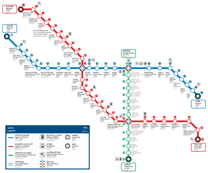
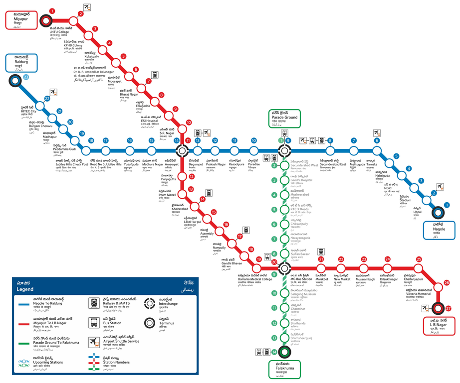
Transit Map of Hyderabad Metro
Summary
edit
| Description |
English: Updated Transit Map of Hyderabad Metro |
| Date | |
| Source | https://www.ltmetro.com/metro-network-map/ |
| Author | HYDERABAD METRO RAIL |
Licensing
edit
This file is licensed under the Creative Commons Attribution-Share Alike 4.0 International license.
- You are free:
- to share – to copy, distribute and transmit the work
- to remix – to adapt the work
- Under the following conditions:
- attribution – You must give appropriate credit, provide a link to the license, and indicate if changes were made. You may do so in any reasonable manner, but not in any way that suggests the licensor endorses you or your use.
- share alike – If you remix, transform, or build upon the material, you must distribute your contributions under the same or compatible license as the original.
File history
Click on a date/time to view the file as it appeared at that time.
| Date/Time | Thumbnail | Dimensions | User | Comment | |
|---|---|---|---|---|---|
| current | 03:30, 19 January 2020 | | 5,157 × 4,298 (4.64 MB) | Madhav165 (talk | contribs) | w.e.f 29 Nov 2019 |
| 14:42, 18 May 2019 |  | 5,157 × 4,298 (6.02 MB) | Anirudh Emani (talk | contribs) | w.e.f 18 May 2019 | |
| 17:20, 15 April 2019 |  | 5,157 × 4,298 (6.02 MB) | Anirudh Emani (talk | contribs) | w.e.f Apr 15 2019 | |
| 14:14, 3 April 2019 |  | 5,157 × 4,298 (5.62 MB) | Anirudh Emani (talk | contribs) | w.e.f April 03 2019 | |
| 15:52, 28 March 2019 |  | 5,157 × 4,298 (6.15 MB) | Anirudh Emani (talk | contribs) | w.e.f 20 March 2019 | |
| 10:23, 26 November 2018 |  | 1,496 × 1,262 (715 KB) | Lakshmikarthik007 (talk | contribs) | User created page with UploadWizard |
You cannot overwrite this file.
File usage on Commons
The following 16 pages use this file:
- User:Chumwa/OgreBot/Potential transport maps/2019 April 1-10
- User:Chumwa/OgreBot/Potential transport maps/2019 April 11-20
- User:Chumwa/OgreBot/Potential transport maps/2019 March 21-31
- User:Chumwa/OgreBot/Potential transport maps/2019 May 11-20
- User:Chumwa/OgreBot/Potential transport maps/2020 January 11-20
- User:Chumwa/OgreBot/Public transport information/2019 April 1-10
- User:Chumwa/OgreBot/Public transport information/2019 April 11-20
- User:Chumwa/OgreBot/Public transport information/2019 May 11-20
- User:Chumwa/OgreBot/Public transport information/2020 January 11-20
- User:Chumwa/OgreBot/Transport Maps/2019 April 1-10
- User:Chumwa/OgreBot/Transport Maps/2019 April 11-20
- User:Chumwa/OgreBot/Transport Maps/2019 May 11-20
- User:Chumwa/OgreBot/Transport Maps/2020 January 11-20
- User:Chumwa/OgreBot/Travel and communication maps/2019 April 1-10
- User:Chumwa/OgreBot/Travel and communication maps/2019 April 11-20
- User:Chumwa/OgreBot/Travel and communication maps/2019 May 11-20
File usage on other wikis
The following other wikis use this file:
- Usage on de.wikipedia.org
- Usage on en.wikipedia.org
- Usage on eo.wikipedia.org
- Usage on te.wikipedia.org