File:Hydrologic unit map, South Carolina LOC 97683355.jpg

Size of this preview: 777 × 600 pixels. Other resolutions: 311 × 240 pixels | 622 × 480 pixels | 995 × 768 pixels | 1,280 × 988 pixels | 2,560 × 1,976 pixels | 3,334 × 2,574 pixels.
Original file (3,334 × 2,574 pixels, file size: 1.22 MB, MIME type: image/jpeg)
Captions
Captions
Add a one-line explanation of what this file represents
Summary edit
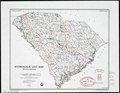
| Description |
English: "July 1991, 1002450." In lower right margin: Revised September 1981 base 4-R-37671. Includes sources of data. Available also through the Library of Congress Web site as a raster image. |
||
| Title | Hydrologic unit map, South Carolina | ||
| Shelf ID | G3911.C3 1991 .U5 | ||
| Date | |||
| Source | https://www.loc.gov/item/97683355/ | ||
| Author | United States. Soil Conservation Service; National Cartographic Center (U.S.) | ||
| Permission (Reusing this file) |
|
||
| Other versions |
|
||
| Location | South Carolina · United States · South Carolina. | ||
| Part of | American Memory · Catalog · Geography And Map Division · Additional Conservation And Environment Cartographic Items | ||
| Subject | South Carolina · Maps · Hydrology · United States |

Licensing edit
| This work is from the Library of Congress. According to the library, there are no known copyright restrictions on the use of this work. |  |
File history
Click on a date/time to view the file as it appeared at that time.
| Date/Time | Thumbnail | Dimensions | User | Comment | |
|---|---|---|---|---|---|
| current | 21:22, 21 August 2018 | | 3,334 × 2,574 (1.22 MB) | Fæ (talk | contribs) | LOC Maps https://www.loc.gov/item/97683355/ #759 |
You cannot overwrite this file.
File usage on Commons
The following page uses this file: