File:ILroute-60A.png

Size of this preview: 304 × 599 pixels. Other resolutions: 121 × 240 pixels | 243 × 480 pixels | 926 × 1,826 pixels.
Original file (926 × 1,826 pixels, file size: 1.9 MB, MIME type: image/png)
Captions
Captions
Add a one-line explanation of what this file represents
Summary edit
| Description |
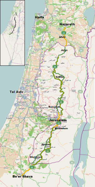
English: Israel Highway 60, highlighted Yellow sections - yellow (Israeli) license plates only. Yellow/Green sections - Both yellow (Israeli) and green (Palestinian) license plates permitted. Green Dotted sections - green (Palestinian) license plates only. Dotted sections, no longer designated Route 60, indicate original route through West Bank cities (Dhahiriya, Hebron, Bethlehem, Ramallah, Nablus, Jenin) prior to construction of bypasses. No bypass has been built around Jenin. |
| Date | |
| Source | OpenStreetMap |
| Author | additions and English labels by Atefrat |
| Permission (Reusing this file) |
The original map is made available under the Open Database License: http://opendatacommons.org/licenses/odbl/1.0/. |
Licensing edit
I, the copyright holder of this work, hereby publish it under the following license:
This file is licensed under the Creative Commons Attribution-Share Alike 3.0 Unported license.
- You are free:
- to share – to copy, distribute and transmit the work
- to remix – to adapt the work
- Under the following conditions:
- attribution – You must give appropriate credit, provide a link to the license, and indicate if changes were made. You may do so in any reasonable manner, but not in any way that suggests the licensor endorses you or your use.
- share alike – If you remix, transform, or build upon the material, you must distribute your contributions under the same or compatible license as the original.
File history
Click on a date/time to view the file as it appeared at that time.
| Date/Time | Thumbnail | Dimensions | User | Comment | |
|---|---|---|---|---|---|
| current | 19:43, 17 July 2023 | | 926 × 1,826 (1.9 MB) | Atefrat (talk | contribs) | new realignment |
| 19:26, 11 April 2022 |  | 926 × 1,826 (1.9 MB) | Atefrat (talk | contribs) | fix minor errors in last update | |
| 18:40, 29 November 2020 |  | 926 × 1,826 (1.91 MB) | Atefrat (talk | contribs) | update | |
| 16:56, 1 February 2019 |  | 926 × 1,826 (1.9 MB) | Atefrat (talk | contribs) | minor detail | |
| 08:45, 29 August 2013 |  | 926 × 1,826 (1.92 MB) | Atefrat (talk | contribs) | inset for wider context | |
| 09:32, 7 August 2013 |  | 926 × 1,826 (1.84 MB) | Atefrat (talk | contribs) | details | |
| 08:55, 7 August 2013 |  | 926 × 1,826 (1.84 MB) | Atefrat (talk | contribs) | User created page with UploadWizard |
You cannot overwrite this file.
File usage on Commons
The following 13 pages use this file:
- User:Chumwa/OgreBot/Potential transport maps/2019 February 1-9
- User:Chumwa/OgreBot/Transport Maps/2019 February 1-9
- User:Chumwa/OgreBot/Transport Maps/2020 November 21-30
- User:Chumwa/OgreBot/Transport Maps/2022 April 11-20
- User:Chumwa/OgreBot/Transport Maps/2023 July 11-20
- User:Chumwa/OgreBot/Travel and communication maps/2019 February 1-9
- User:Chumwa/OgreBot/Travel and communication maps/2020 November 21-30
- User:Chumwa/OgreBot/Travel and communication maps/2022 April 11-20
- User:Chumwa/OgreBot/Travel and communication maps/2023 July 11-20
- User:Geagea/Culture of Israel/2019 February 1
- User:Geagea/Geography of Israel/2019 February 1
- User:Geagea/Society of Israel/2019 February 1
- Category:B60 (Israel/Palestine)
File usage on other wikis
The following other wikis use this file:
- Usage on ar.wikipedia.org
- Usage on en.wikipedia.org
- Usage on ja.wikipedia.org
- Usage on ko.wikipedia.org
- Usage on pl.wikipedia.org
- Usage on www.wikidata.org