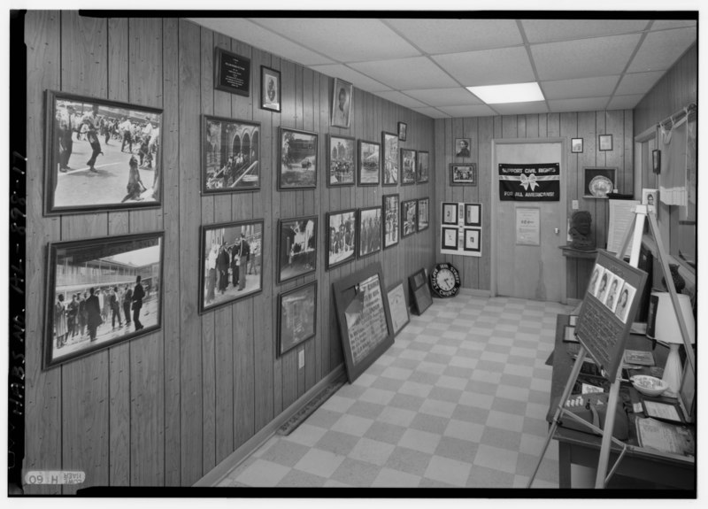
File:INTERIOR VIEW OF BASEMENT EXHIBITION OF EVENTS OF CIVIL RIGHTS MOVEMENT AND THE 1963 BOMBING OF THE CHURCH, LOOKING SOUTH - Sixteenth Street Baptist Church, 1530 Sixth Avenue HABS ALA,37-BIRM,33-17.tif
Size of this JPG preview of this TIF file: 800 × 575 pixels. Other resolutions: 320 × 230 pixels | 640 × 460 pixels | 1,024 × 736 pixels | 1,280 × 920 pixels | 2,560 × 1,840 pixels | 5,000 × 3,593 pixels.
Original file (5,000 × 3,593 pixels, file size: 17.14 MB, MIME type: image/tiff)
Captions
Captions
Add a one-line explanation of what this file represents
Summary edit
| INTERIOR VIEW OF BASEMENT EXHIBITION OF EVENTS OF CIVIL RIGHTS MOVEMENT AND THE 1963 BOMBING OF THE CHURCH, LOOKING SOUTH - Sixteenth Street Baptist Church, 1530 Sixth Avenue North, Birmingham, Jefferson County, AL | ||||
|---|---|---|---|---|
| Title |
INTERIOR VIEW OF BASEMENT EXHIBITION OF EVENTS OF CIVIL RIGHTS MOVEMENT AND THE 1963 BOMBING OF THE CHURCH, LOOKING SOUTH - Sixteenth Street Baptist Church, 1530 Sixth Avenue North, Birmingham, Jefferson County, AL |
|||
| Depicted place | Alabama; Jefferson County; Birmingham | |||
| Dimensions | 5 x 7 in. | |||
| Current location |
Library of Congress Prints and Photographs Division Washington, D.C. 20540 USA http://hdl.loc.gov/loc.pnp/pp.print |
|||
| Accession number |
HABS ALA,37-BIRM,33-17 |
|||
| Credit line |
|
|||
| Source | https://www.loc.gov/pictures/item/al0966.photos.321049p | |||
| Permission (Reusing this file) |
|
|||

| Camera location | | View this and other nearby images on: OpenStreetMap |
|---|
File history
Click on a date/time to view the file as it appeared at that time.
| Date/Time | Thumbnail | Dimensions | User | Comment | |
|---|---|---|---|---|---|
| current | 18:46, 30 June 2014 |  | 5,000 × 3,593 (17.14 MB) | Fæ (talk | contribs) | GWToolset: Creating mediafile for Fæ. HABS batch upload 29 June 2014 (101:150) |
You cannot overwrite this file.
File usage on Commons
The following page uses this file: