File:ISS-36 Galveston Island 2.jpg

Original file (2,832 × 4,256 pixels, file size: 835 KB, MIME type: image/jpeg)
Captions
Captions
Summary edit
| DescriptionISS-36 Galveston Island 2.jpg |
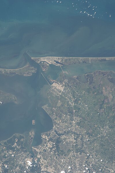
English: Satellite picture: Galveston Island runs from just left of top center through top right of the image, and the Bolivar Peninsula, highly impacted by Hurricane Ike five years ago, is the land mass at top left — Texas.
|
| Date | |
| Source | http://spaceflight.nasa.gov/gallery/images/station/crew-36/html/iss036e037751.html |
| Author | NASA |
This image or video was catalogued by Johnson Space Center of the United States National Aeronautics and Space Administration (NASA) under Photo ID: ISS036-E-037751. This tag does not indicate the copyright status of the attached work. A normal copyright tag is still required. See Commons:Licensing. Other languages:
العربية ∙ беларуская (тарашкевіца) ∙ български ∙ català ∙ čeština ∙ dansk ∙ Deutsch ∙ English ∙ español ∙ فارسی ∙ français ∙ galego ∙ magyar ∙ հայերեն ∙ Bahasa Indonesia ∙ italiano ∙ 日本語 ∙ македонски ∙ മലയാളം ∙ Nederlands ∙ polski ∙ português ∙ русский ∙ sicilianu ∙ slovenščina ∙ Türkçe ∙ українська ∙ 简体中文 ∙ 繁體中文 ∙ +/− |
Licensing edit
| Public domainPublic domainfalsefalse |
This file is in the public domain in the United States because it was created by the Image Science & Analysis Laboratory, of the NASA Johnson Space Center. NASA copyright policy states that "NASA material is not protected by copyright unless noted". (NASA media use guidelines or Conditions of Use of Astronaut Photographs).
Photo source: ISS036-E-37751.
العربيَّة | Deutsch | English | español | français | italiano | kurdî | македонски | മലയാളം | português | sicilianu | +/− |
File history
Click on a date/time to view the file as it appeared at that time.
| Date/Time | Thumbnail | Dimensions | User | Comment | |
|---|---|---|---|---|---|
| current | 23:50, 1 September 2013 |  | 2,832 × 4,256 (835 KB) | Ras67 (talk | contribs) | == {{int:filedesc}} == {{Information |Description={{en|1=One of the Expedition 36 crew members aboard the International Space Station on Aug. 28 photographed this vertical image that shows much of Galveston County and a small portion of southeast Harri... |
You cannot overwrite this file.
File usage on Commons
The following 2 pages use this file:
Metadata
This file contains additional information such as Exif metadata which may have been added by the digital camera, scanner, or software program used to create or digitize it. If the file has been modified from its original state, some details such as the timestamp may not fully reflect those of the original file. The timestamp is only as accurate as the clock in the camera, and it may be completely wrong.
| Camera manufacturer | NIKON CORPORATION |
|---|---|
| Camera model | NIKON D3S |
| Exposure time | 1/250 sec (0.004) |
| F-number | f/8 |
| ISO speed rating | 100 |
| Date and time of data generation | 16:48, 28 August 2013 |
| Lens focal length | 180 mm |
| Orientation | Normal |
| Horizontal resolution | 300 dpi |
| Vertical resolution | 300 dpi |
| Software used | Adobe Photoshop CS6 (Windows) |
| File change date and time | 16:27, 28 August 2013 |
| Exposure Program | Normal program |
| Exif version | 2.21 |
| Date and time of digitizing | 16:48, 28 August 2013 |
| APEX shutter speed | 7.965784 |
| APEX aperture | 6 |
| APEX exposure bias | 0 |
| Maximum land aperture | 3 APEX (f/2.83) |
| Metering mode | Pattern |
| Light source | Unknown |
| Flash | Flash did not fire |
| DateTime subseconds | 46 |
| DateTimeOriginal subseconds | 46 |
| DateTimeDigitized subseconds | 46 |
| Color space | sRGB |
| Sensing method | One-chip color area sensor |
| File source | Digital still camera |
| Scene type | A directly photographed image |
| Custom image processing | Normal process |
| Exposure mode | Auto exposure |
| White balance | Auto white balance |
| Digital zoom ratio | 1 |
| Focal length in 35 mm film | 180 mm |
| Scene capture type | Standard |
| Scene control | None |
| Contrast | Normal |
| Saturation | Normal |
| Sharpness | Normal |
| Subject distance range | Unknown |
| Serial number of camera | 2053892 |
| Lens used | 180.0 mm f/2.8 |
| Date metadata was last modified | 11:27, 28 August 2013 |
| Rating (out of 5) | 0 |
| Unique ID of original document | 5D85C1AF61DB6A6141857AC1CA57CAD2 |